The study of Geography would be infinitely less interesting without maps. It would also be far more difficult. Geographers are interested in understanding and explaining spatial patterns. Whether those patterns are found in the distribution of specific plant species in a forest community, in variations in zoning regulations between counties, or in popularity of one tourist destination over another, maps are essential to breathing life into those patterns.
Noted cartographer and graphic designer Denis Wood, in his decades-long project mapping the Raleigh, North Carolina, neighborhood of Boylan Heights and related works, refers to maps as a narrative, as an argument made about a place. Rather than simply a representation of the real world or a snapshot of a place in time, the intent of maps—from their content to their intended audience, their scale to their design—are more a reflection of those who create the map than they are of the subject in question. This view of cartography, of critical cartography, can (and should) be political: how does power and position affect the ability of one group of people to “create” place, either through maps or through action?
Yet there is a more expressive part of cartography that is also suggested by these approaches. If maps are simply about illustrating spatial patterns, why are so many maps hanging on walls as pieces of ‘art’? Therein lies the fundamental balance of Geography as a discipline wedged between the Sciences and the Arts and of cartography’s role in maintaining that balance. Creativity in mapping can seem at odds with the purpose of cartography if one views it as creating a representation of space; when one views it as a narrative of place, creativity becomes much more important. (That distinction gets rather fuzzy in this age of digital maps, when users may trust their maps to be accurate even if they really aren’t.)
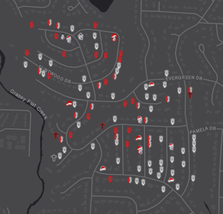
This map is the result of a quick Winter Break exercise, completed just in time for Christmas, showcasing the expressive cartography concept described above. An homage to the neighborhood examinations put forth by Wood in Boylan Heights, this map and the related project—found in the direct link from the image above—show the illuminated exterior holiday decorations in a portion of Little Rock’s Leawood neighborhood. What do the patterns mean? How are we to interpret the narrative of place that the map suggests?
The truth is you’re not. It’s just one map of a neighborhood. A map produced with numerous assumptions and limitations (for example, only houses with illuminated displays were recorded, leaving solitary, unlit, door-hung wreaths unmarked) can hardly be enough to capture the sense of place this neighborhood, or any other. Paired with a series of spatial records, we might be able to capture the sense of what is here and what it means to be part of Leawood. At the very least, however, this single map should give rise to questions about spatial patterns in the data. Why are there so few religious displays in a state where religion is clearly a major part of the social landscape? Why are high-traffic roads more likely to have homes with white lights?
To a Geographer, that is the power of a map. There may be no answers to those questions—or perhaps no definitive answers. But a map, whether made as a piece of Art or as record of Science, is an opening to a more comprehensive understanding of place. Show me a Geographer not interested in pouring over a map and I’ll show you a Geographer not interested in the core curiosities of their own discipline.
Maps are our tools, but they are also our voice; they allow us to translate the places and spaces we study into a form digestible to others. It is important as trained cartographers that we understand both how our data are best represented as well as how our audience will interpret that representation. As educators, we should also help non-Geographers critically examine maps. To understand their origin, intent, and message, not simply the visible patterns displayed. It is in those elements of a map where we can find the most interesting facets of Geography.

