The following is an excerpt from: 2023 Preliminary Survey and Excavation at the Wright House Property (St. John’s House) at Powhatan Historic State Park. Report submitted to Arkansas Department of Parks, Heritage, and Tourism and the Arkansas Archeological Survey.
This report summarizes results of survey and excavations undertaken at the Wright House (St. John’s House) property at Powhatan Historic State Park from March 18 through 23, 2023. The St. John’s House was constructed in the early 1860s by William and Emmaline Baird. This was at a time during which Powhatan was established as the Lawrence County seat in 1868, and shortly before the construction of the original 1873 courthouse. Thus, the St. John’s House is important as it relates to the founding and development of the town of Powhatan.
The Baird family owned and operated the St. John’s House until 1871 when the property was purchased by Elizabeth Ann and Jesse E. Thompson and became the Thompson Hotel. George Thornburgh owned and operated the hotel from 1875 until 1886. After several different owners, the Rex family bought the property in 1912 and ran the Rex Boarding House until 1953. In the early 1950s the St. John’s House was razed and select portions of the foundation and a cistern (CS1) of the original building was incorporated into the Wright House, which is the current building located on the property. According to deed records, the St. John’s House was located on Block 9, Lot 6 and likely extended into a section of Block 9, Lot 5 (Figure 1).
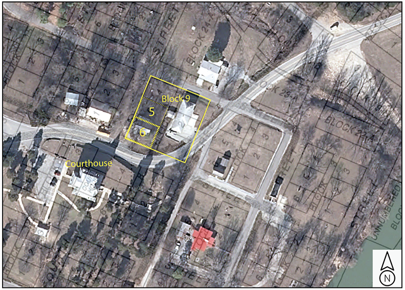
Figure 1. Location of Block 9, Lots 5 and 6.
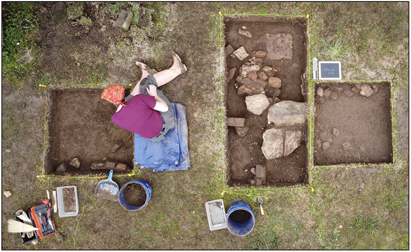
The Wright House is currently unoccupied (and partially damaged) and scheduled for demolition. In order to assess the potential for archaeological subsurface features, to evaluate the interpretive integrity of buried remains, and to identify and document select architectural components associated with the former St. John’s House, an archaeological survey of the property was requested by Arkansas State Parks and undertaken by the Jamie C. Brandon Center for Archaeological Research (JCB Center). Personnel associated with the field work was highly collaborative, and included two undergraduate archaeology students from the University of Central Arkansas (UCA) and University of Arkansas-Little Rock (UALR), the director of the Faulkner County Museum, director of the JCB Center, and local volunteer Breanna Wilbanks- Elledge (Figure 2).
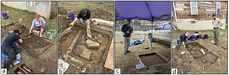
Figure 2. Contributing personnel. (a) UCA student Ashley Hansen; UALR student Adam Orr. (b) Faulkner County Museum director, Lynita Langley-Ware. (c) JCB Center director, Dr. Duncan McKinnon. (d) Local volunteer, Breanna Wilbanks-Elledge, with Park Interpreter Zachary Elledge.
Over the course of six days, archaeological field work consisted of several targeted test excavations (seven Units) around the current Wright House. Additionally, an electrical resistivity survey was performed in order to assess the nature and distribution of buried features across the project area. Preliminary testing associated with this field work was focused on the external and accessible locations on the property within the proposed project area (Block 9, Lots 5, 6). Data collection did not include spaces under or within the current Wright House, and avoided areas with significant accumulated debris, such as around the back of the structure. No formalized documentation of the current structure was undertaken, although drone imagery was collected in order to document the relationship of the Wright House to targeted excavation test areas. For this initial field work, the purpose was to identity and evaluate the integrity of select buried archaeological features in the accessible project area to assist Powhatan Historic State Park in their long-term planning, and to allow for the protection of archaeological areas to be avoided during the razing of the Wright House. Results document several features that are interpreted as architectural features associated with the St. John’s House and demonstrate that buried archaeological features are present throughout the study area.
HISTORIC PHOTOS AND CONTEMPORARY SITE ORGANIZATION
Deed records indicate the St. John’s Boarding House was a wood frame house composed of limestone and brick substructure footings and foundation walls. Historic photographs of the building highlight that it was a two-story structure with a basement or cold storage area. An historic photograph (ca. 1930s) offers of a view of the building (at that time the Rex Boarding House) and its architectural features (Figure 3). The roof was a cross open gable roof with the tops of two chimneys visible in the photograph. Various outbuildings block the view of some of the structure. However, the current landscape within Lots 6 and 5 slopes downward from Highway 25 (formerly Main St.) and toward the back of Block 9 to Ficklin Street (see also Figure 1). Thus, it can be assumed that a natural landform sloped downward, such that the first floor was at ground level at the front of the structure (facing the courthouse) and projected over a basement or cold storage to the rear of the structure.
A dilapidated porch is visible on the east side with accessibility underneath. A stone veneer is visible underneath the porch, which curves around to the back of the building. A small window or door within the veneer is along the back wall. While not tested during this initial work, a large cistern (CS1) is located under the current Wright House in the approximate location of the small window or door along the stone veneer in the photograph. Note that a second cistern (CS2, discussed below) was discovered on the east end in a proposed proximity to the porch.
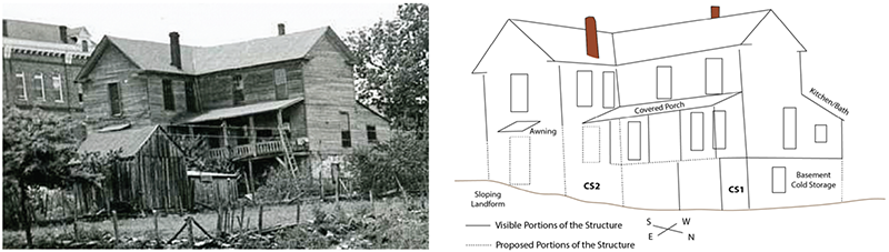
Figure 3. St John’s House looking westward toward the structure. The 1888 courthouse is visible in the background.
There is a small awning over a window or door to the east, which visually obstructed by a wooden shed. There are no known photographs documenting the west side, although a small first-floor enclosed vestibule is visible. A preliminary suggestion is this architectural feature represents a kitchen or bath area. Excavations (see Trench Unit 1 below) document drainage and sewer pipes in this area.
A second historic photograph (ca. 1940s) provides a view of the front of the building (Figure 4a). Attached to the gable roof is a recessed dormer with a central second story window. This is proposed to be the location of the internal central staircase where the second story window is located at the end of a hallway accessing rooms to each side. The chimney on the west is visible and is likely an external chimney centered on the gable end. This suggests that the west side first-floor vestibule does not extend across the entire west side (see Figure 3). A large covered porch is also visible on the front of the house along Main Street facing the courthouse.
A third historic photograph (ca. 1930s) is a view from the Black River looking west toward the downtown area (Figure 4b). The courthouse and St. John’s House are situated on a topographic rise above the river. The profile of the front porch of the St. John’s House is visible, along with portions of the side or east porch. Excavations (see Units 2, 4, 5) identified foundational footings associated with the southeast corner of the front porch. The opening below the awning on the east end (see Figure 3) is visible as a large window. The large window suggests the location of a communal parlor or sitting room with a fireplace on the north wall (the central chimney, see Figure 3) and view of the Black River from a large picture window on the east outside wall. In the photograph, the old suspension bridge is visible to the left (south), in which traffic exited the bridge directly between the courthouse and the St. John’s Boarding House. Its relationship to the courthouse and main throughfare through Powhatan highlights its existence as one of the larger buildings centrally located within the town that certainly received many visitors to Powhatan during its operation. It further highlights the value of documenting and evaluating the former location of the St. John’s Boarding House using historical and archaeological methods.
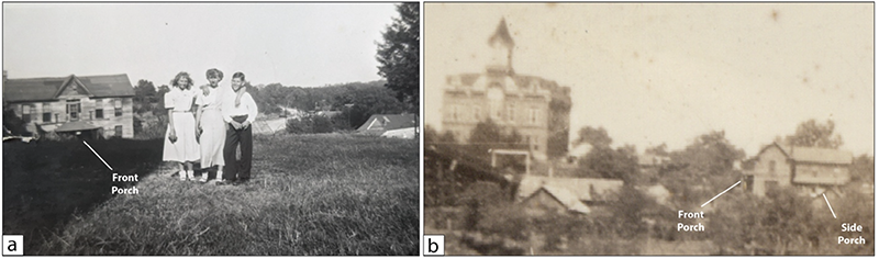
Figure 4. Additional view of the St John’s/Rex Boarding House. (a) A view looking from the courthouse lawn toward the north. (b) a view from the Black River looking westward toward the courthouse and the boarding house.
DRONE SURVEY
In order to assess the distribution of contemporary landscape and architectural features, document overall site organization of Block 9, and create a base map reference to associate excavation units and electrical resistivity data, low-altitude drone imagery was collected during field work (Figure 5). The use of drone imagery in archaeological applications has gained momentum in recent years and offers the ability to obtain high-resolution vertical imagery, as well as its use in documenting excavation units and localized features (see Campana 2017). Permission was granted from Arkansas State Parks for the use of the drone on the property, where imagery of periphery properties (neighbors) was not collected in the interest of privacy.
Thirteen high-resolution images were collected at an altitude of 150 feet and “stitched” together using open-source photogrammetry concatenation software. As demonstrated, the current Wright House is located on both Block 9, Lot 6 and 5 along Fourth Street to the west (now a dirt road). The front of the property faces Highway 25. Block 9, Lot 4 contains no extant buildings, apart from raised garden plots. Some targeted excavations were focused in the front of the property, and excavation units (and archaeologists) are visible in this area. Additional units were opened after the drone imagery was collected. Heavy structural damage to the back of the Wright House is clearly visible, where debris had accumulated and prohibited test excavation in that area. Generalized interior room designations are listed (in red), with the kitchen located to the back of the house and proximate to exterior buried drainage and sewer lines (see Trench Unit 1). The Powhatan Historic State Park offices are located to the east in Block 9, Lots 1, 2, and 3.
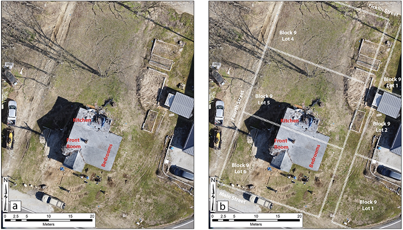
Figure 5. Drone imagery collected on March 20, 2023. (a) View at 150 feet. (b) View at 150 feet with estimated Block 9 boundaries overlain.
ELECTRICAL RESISTIVITY SURVEY
The use of terrestrial-based remote sensing methods in archaeology (archaeogeophysics) has developed into an applied discipline with the use of data to interpret landform changes, guide excavation, and establish subsurface distribution maps of cultural and natural features (see McKinnon and Haley 2017). Several methods are utilized, which include magnetic gradiometry, electrical resistance, ground-penetrating radar, and magnetic susceptibility (see Johnson 2006). For this field work, an electrical resistance survey was undertaken.
Electrical resistance surveys measure the level of resistance (R) in the subsurface by injecting a current (I) into the ground using a low voltage (V) resistance meter. The ratio of current to voltage defines resistance and is expressed by Ohm’s Law, mathematically stating that R=I/V. While resistance is an electrical quality, resistivity is the actual specific property of the material. Its conversion allows for the “resistance of different materials to be compared in a standardized way” (Clark 1996:27). Electrical resistivity is measured in ohm-meters.
Variations in resistance measurements are based on the principle that geological features hold different materials and amounts of moisture. Both exhibit varying levels of resistance to an electrical current, and the latter has a particularly large effect in archaeological sites. As a general principle, these varying levels of high resistance (low conductivity) might represent a shallow subsurface of compressed soil matrix, such as a compacted buried surface where porosity is decreased and evaporation is elevated. In contrast, a measurement of low resistance (high conductivity) might represent a pit or depression where moisture has accumulated into a more porous soil matrix (void) and is less likely to evaporate–or at least evaporate at a slower rate.
At the Wright House property, three whole and partial 20 x 20-meter grids (approx. 65.5 x 65.5 feet) were established in order to encompass most of the accessible property area in Lots 4, 5, and 6 (Figure 6). Electrical resistivity was collected within each 20 x 20-meter grid with spacing between transects (Y) and along the baselines (X) each set to half-meter spacing. Current (I) ranges were set to 1 mA at an output voltage (V) of 40 V allowing for a resolution of 0.0005 ohms. Data were collected zigzag (collecting while walking back and forth) using an RM Frobisher TAR-3 resistance meter.
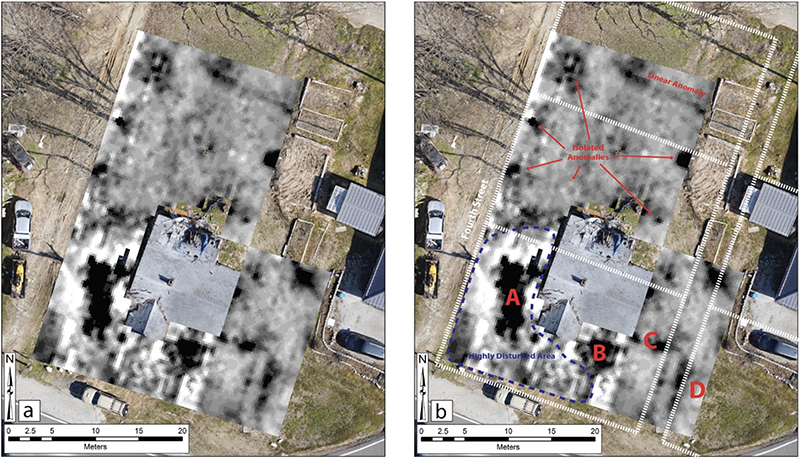
Figure 6. Electrical resistivity results. (a) Survey area showing processed data and no interpretations. (b) Survey area highlighting mapped anomalies in black (high resistance) and white (low resistance).
Results reveal that the area to west, and portions of the south (front) of the Wright House structure is heavily disturbed (outlined in blue). Numerous high and low resistance anomalies are present in the area However, some patterns are present. For example, there is a large high resistance anomaly (A) directly to the west of the structure and situated beneath compacted earth and fill in the former location of a car park. It may represent compacted earth as a result of the car park, but is also in the general location of the proposed gable-end chimney of the St. John’s House and could define the remains of brick debris associated with a chimney fall located on the west gable end (see Figure 4). This anomaly was not tested during field work.
In the south (front) and east, two isolated high resistance anomalies (B and C) were tested. Anomaly B is located about two meters (6 feet) from the front of the current Wright House, whereas Anomaly C is located about three meters (10 feet) east along a linear anomaly that runs outward and is in alignment with the current house foundation wall on the front. Both anomalies were tested to reveal two features that include the remains of a brick footing (Anomaly B; Unit 2) and stone and brick foundation stone (Anomaly C; Unit 3). Anomaly D represents a high resistance linear feature that is perpendicular to Anomaly C, and may represent a buried structural feature. It was not tested. Behind the structure in Lot 5 are several isolated anomalies that likely represent tree roots or the former location of trees.
TARGETED EXCAVATIONS
Six targeted excavation units and one excavation Trench represent the extent of targeted excavation locations (Figure 7). Four units (U1, U2, U4, U5) were placed to the front of the Wright House. Two Units (U3 and U6) were placed to the east. A single Trench (TU1) was placed behind the house. The placement of each unit was based on a combination of electrical resistivity results, visible surface features, and features exposed using a backhoe testing.
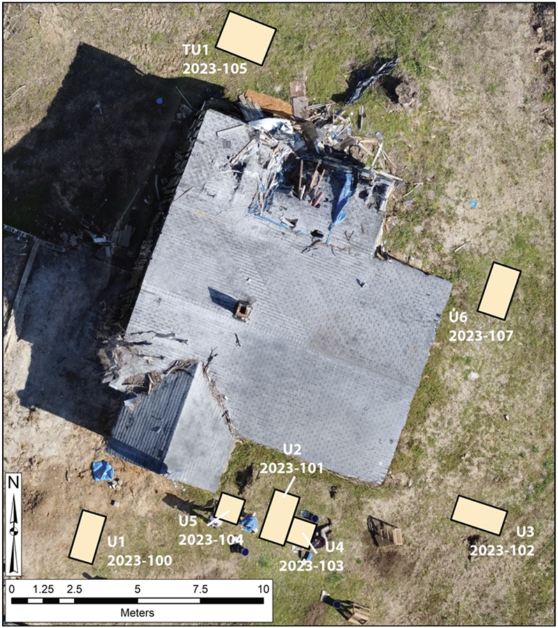
Figure 7. Location of excavation Units in relation to the current Wright House. Units are labeled with associated artifact feature numbers.
Unit 1 (2023-100)
Unit 1 is a 1 x 2 m unit that was placed in front of the Wright House based on the presence of surface features (see Figure 7). A single excavation at 15 cm revealed a compact layer of gravel with loose brick and stone positioned on the gravel (Figure 8). Artifacts recovered from Unit 1, Level 1 (2023-100-01) include a minor amount of glass and nails, and contemporary plastic debris (n = 32, 289.9 g). No architectural features were identified.
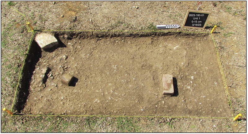
Figure 8. Unit 1, Level 1 (2023-100-01). Note compacted gravel and bricks and stones resting on gravel.
Unit 2 (2023-101)
Unit 2 is a 1 x 2 m unit that was placed directly in front of the Wright House based on electrical resistivity results (Anomaly B) and visible surface features (see Figures 6 and 7). Level 1 (0-15 cm) revealed the top portion of Feature 1, a linear feature consisting of large limestone and early forms of brick (Figure 9a). Recovered artifacts (2023-101-01) are fairly diverse (n = 90, 284.1 g) and consist of a combination of contemporary (late twentieth to early twenty-first century) and early nineteenth century items. Contemporary items include plastic objects, mid-twentieth century ceramics, and wire nails. Late nineteenth century artifacts are contemporaneous with the St. John’s House and include cut nails (see Adams 2002; Nelson 1968; Wells 1998) and a potential free-blown bottle (2023-101-01-01-02; see Newman 1970). Small broken fragments of plate window glass (n = 23) were also recovered (see Roenke 1977).
Level 2 (15-30cm) revealed the extent of Feature 1 as brick and limestone debris (Figure 9b). The base of the pillar is visible in the northeast corner of the unit. The large limestones to the south of the unit may represent the remains of former steps to the porch platform. Artifacts in Level 2 (2023-101-02) were plentiful (n = 171, 1039.1 g), where glass (n = 60, 240 g) and nails (n = 93, 555.3 g) represent the highest quantities. A concentration of large fragments of plate window glass was recovered within Feature 1. Additionally, a broken base of a rectangular medicine or pharmacy prescription bottle from a Missouri druggist was recovered (2023-101-02-01-03; Figure 10a). The bottle fragment is broken and the name of the druggist and city of origin is unknown, although perhaps it was made by the Missouri Glass Company (MoGCo.). The rectangular shape with rounded edges and embossing was common between the late nineteenth and early twentieth centuries (Farnsworth 2015). A second medicine or pharmacy prescription bottle was also recovered (2023-101-02-01-03; Figure 10b). It contains no visible embossing, but has a similar shape with rounded edges and likely dates to the same time period.
Nails included late nineteenth and early twentieth century large structural nails (> 4 inches), cut nails for framing (2-4 inches), finishing nails (< 2 inches), and cut nail spikes (Figure 10c). A few roofing nails were recovered, and relate to the post-1950s Wright House building.
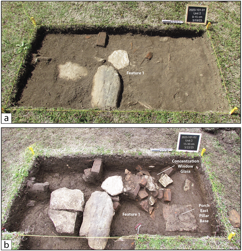
Figure 9. Unit 2 (2023-101) located at the front of the Wright House. (a) Level 1 (0-15 cm; 2023- 101-01) and Feature 1. (b) Level 2 (15-30 cm; 2023-101-02) with Feature 1 exposed. Note location of window glass concentration, and the east pillar base of a former porch.
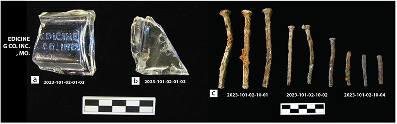
Figure 10. Select artifacts from Unit 2, Level 2. (a) Base of medicine bottle with embossing. (b) Base of rectangular medicine bottle with no embossing. (c) Cut nails of varying sizes and forms.
Feature 1 is interpreted as the brick and limestone remains of the porch pillar support located on the east side of the front porch. The pillar is a 1 x 1 ft (30 x 30 cm) square base with brick debris clustered to the northeast (see Figure 9b). In an historic photograph (ca. 1940s) the roof and east and west pillars of a front porch are clearly visible (Figure 11; see also Figure 4a). Furthermore, the concentration of large broken pane glass (2023-101-02-01-01) in Feature 1 is interpreted as the debris remains from a window located proximate to the east porch pillar on the front of the structure.
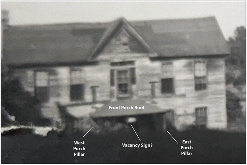
Figure 11. Close-up of historic (ca. 1940s) image of the St. John’s House (called the Rex House at this time).
Unit 4 (2023-103) and Unit 5 (2023-104)
Units 4 and 5 were opened in order to better understand the extent of Feature 1 in Unit 2 (see Figure 7 and 9). Unit 4 is a 1 x 1 m unit that was opened to the east of Unit 2. Level 1 (0-30 cm) revealed a small cluster of stone and brick in the northwest corner that was assigned as Feature 3 (Figure 12a). Artifacts from Unit 2, Level 1 (2023-103-01) are minor (n = 45, 180.6 g) and consist of mostly contemporary debris.
Unit 5 is a 1 x 1 m unit that was placed 1 m west of Unit 2 (see Figure 7). Level 1 (0-15 cm) revealed a small circular stack of bricks that is defined as Feature 4 (Figure 12b). Artifacts from Unit 5, Level 1 (2023-104-01) were quite diverse and suggest they represent objects that may have been lost, perhaps under a porch. Some items include soda and can caps (2023-104-01- 02, 2023-104-01-03), an automotive key (2023-104-01-07), several pennies (2023-104-01-05), assorted plastic items (2023-104-01-08), small magnets (2023-104-01-04), and a broken (cat?) paw (2023-104-01-06) from a small figurine. Of note is the minor about of plate window glass (n = 5, 7.6 g) and the high amount of cut nails used for framing (2-4 inches) and finishing nails (< 2 inches). The presence of framing and finishing nails (used in porch construction) and lack of window glass (with no windows presumably present within the front porch area) further suggests Unit 5 is proximate to a location under or near the former front porch of the St. John’s structure (see Figure 11).
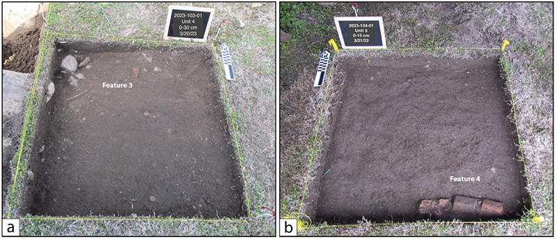
Figure 12. (a) Unit 4, Level 1, Feature 3. (b) Unit 5, Level 1, Feature 4.
Level 2 in both Units 4 and 5 further define Features 3 and 4 (Figure 13). Unit 4, Level 2 (30-45 cm) Feature 3 is a small cluster of limestone in the northwest corner of the unit and perhaps represents the collapsed remains of a stone skirt around the former porch. Artifacts in Unit 4, Level 2 (2023-103-02) were meager (n = 116; 589.6, g). Further testing is necessary to better understand the relationship of Feature 3 to Feature 1.
Feature 4, located in Unit 5, Level 2 (2023-104-02), is an interesting curvilinear feature of stacked bricks located in the south end of the unit (see Figure 13). Bricks are mortared together and represent an in situ feature. Limited time did not allow for a full investigation of Feature 4, which may be associated with the front porch or related to a garden plot feature or pathway in front of the former porch.
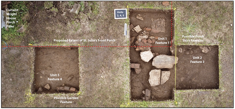
Figure 13. (a) Unit 4, Level 1, Feature 3. (b) Unit 5, Level 1, Feature 4. The proposed extent of the St. John’s Boarding House front porch is outlined in red.
Interestingly, two large iron swinging pivot door hinges were recovered. A single hinge (2023-103-02-01) was recovered from Unit 4, Level 2 (Figure 14a). This hinge mounted to a left door jamb, presumably at the top of the jamb. A second hinge (2023-104-02-03) of the same type was recovered from Unit 5, Level 2 (Figure 14b). This hinge mounted to the right door jamb, also presumably at the top of the jamb. A third broken door hinge (2023-104-02-03) was recovered from Unit 5, Level 2 (Figure 14c). These hinges are seemingly robust when compared to hinges of the same time period (see Streeter 1973, 1975). However, initial interpretations suggest that the hinge hardware supported a swinging door, perhaps the front porch screen mounted on the primary entrance to the St. John’s structure. They could also represent hinges for outside shutters, although historic photographs reveal shutters were not present (see Figure 11).
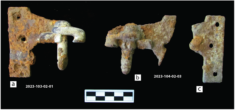
Figure 14. Iron swinging pivot door hinges. (a) Hinge found in Unit 4, Level 2. (b) Hinge found in Unit 5, Level 2. (c) Remans of a broken hinge found in Unit 5, Level 2.
When evaluated together, Units 1, 2, and 4 along the front of the current Wright House shed light on the proposed location and extent of the former St. John’s house porch (see Figure 13). Excavations suggest that the former porch extended beyond the current Wright House porch to the east by three meters (10 feet) and connected to the building in the proximity of the east porch pillar base (Feature 1). A limestone skirt may have been constructed around the bottom of the porch, and a garden feature or pathway may have existed as one approached the primary entrance to the St. John’s Boarding House. Initial testing demonstrates that features related to the St. John’s Boarding House (and later Rex Boarding House) are intact in the subsurface in front of the current Wright House building, and that further testing is necessary in this area.
Unit 3 (2023-102)
Unit 3 is a 1 x 2 m unit that was placed three meters (10 feet) to the east of the Wright House structure (see Figure 7). It is located down-slope from the Wright House location. The location was selected based on the presence of several surface stones aligned in a linear pattern with the front of the Wright House, as well as the identification of a high resistance anomaly (Anomaly C) in the area (see Figure 6). Level 1 (0-30 cm) revealed the top portions of Feature 2, which was initially defined as a jumble of large limestones in the west side of the unit with some exposed brick in the northeast corner (Figure 15a). Large tree or bush roots are mixed within the feature, and represent the remains of a large bush that had been recently removed.
Artifacts from Level 1 (2023-102-01; n = 124, 343.1 g) were fairly minor, yet diverse. They consist of a variety of small pieces of colored bottle glass (2023-102-01- 01-03, 04, 05), mid-twentieth century ceramics (2023-102-01-03), and contemporary plastics (2023-102-01-04). Of note are a number of small window glass fragments (2023-102-01-01-01), which constitute 27 percent of the artifact totals for Level 1 (n = 35, 55.4 g). Given that the location of Unit 3 was placed three meters (10 feet) from the current Wright House, it is suggested that the presence of window glass in Unit 3, Level 1 relates to the extent of the St. John’s structure existing in this area. Additionally, numerous nails of varying sizes (n = 64, 234.7 g) were recovered. The nails represent 51 percent of the artifacts identified in Unit 3, Level 1, and further suggests that Feature 2 is related to the extent of the St. John’s structure.
Level 2 (30-40 cm) further defines Feature 2 as a complex jumble of numerous limestones located in the west of the unit and a large brick cluster in the north portion of the unit. The brick cluster is directly associated and mixed with the limestone jumble (Figure 15b). Most of the brick cluster is a pile of several early whole and fragmented bricks, but it also contains at least two bricks that are lying horizontal with the ground surface. A single limestone is resting over them. These may represent an in situ position, and perhaps the remains of a foundation pillar. Time did not allow further investigations, although initial interpretations propose that Feature 2 represents the components of the former foundation of the St. John’s structure. The density and amount of limestone and brick and its alignment and relationship to the Wright House, suggest that Feature 2 is the location of the corner of the St. John’s building, or a portion along the eastern extent of the building (see discussion below).
Artifacts from Level 2 (2023-102-02) are numerous and diverse (n = 153, 1555.82 g; see Appendix A). Additional fragments of window glass (2023-102-02-06-03) were recovered, further suggesting the presence of a former window in this area. A small rectangular medicine bottle base (ca. late nineteenth to early twentieth century) was recovered with embossing on the front face and both sides (Figure 16a). The bottle is broken with visible lettering only on one side, which likely stated MADE IN U.S.A. (2023-102-02-06-04). Cut nails were even more abundant than those recovered in Level 1, with an emphasis on framing nails (2023-102-02-11- 02; n = 35, 225.5 g) and smaller finishing nails (2023-102-02-11-03; n = 37, 120.02 g) that might be used for wood siding or window trim. Historic photographs highlight that the St. John’s building contained wood siding (see Figure 3). A mule shoe (2023-102-02-08) and a small iron hand crank (2023-102-02-09) were also recovered (Figure 16b). The identification of architectural features in this area demonstrates that buried intact features exist and further testing is necessary to better understand their relationship to documented features and the extent of the former St. John’s Boarding House structure on the east end of the property.
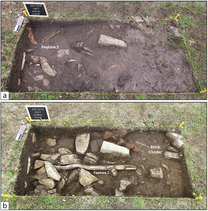
Figure 15. Unit 3 (2023-102). (a) Level 1, Feature 2. (b) Level 2, Feature 2. Note brick cluster to the north.
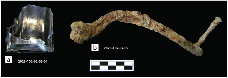
Figure 16. Select artifacts from Unit 3, Level 2. (a) Fragment of medicine bottle. (b) Remains of an iron hand crank.
Unit 6 (2023-107)
Unit 6 is a 1 x 2 m unit that was opened in order to test a slump on the landscape on the northeast corner of the Wright House (see Figure 7). Park maintenance personnel shared that the area regularly slumped and dirt fill is often dumped in the area. Testing exposed Feature 7, which is the remains of a large brick cistern (CS2, Figure 17). In the interest of time, only a portion of the top of Feature 7 was excavated and photographed. Much of the top brick layers are no longer intact and have been removed, perhaps when it was buried. Some debris is present around the exterior, which are likely components of the original form. The internal diameter is 1.5 m (5 feet) and a large void is within the center. Some iron and metal piping are present, but their relationship (and chronology) to the cistern remains unknown. Recovered artifacts (2023-107- 01) are random items that were deposited into the cistern, which include a medicine bottle with a rectangular base (Figure 18). Additional testing is necessary to fully understand type of cistern, depth and construction, and relationship to architectural features, particularly the extant cistern (CS1) located under the current Wright House building (see Figure 3).
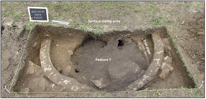
Figure 17. Unit 6, Feature 7. Portions of a cistern on the west side of the current Wright House.
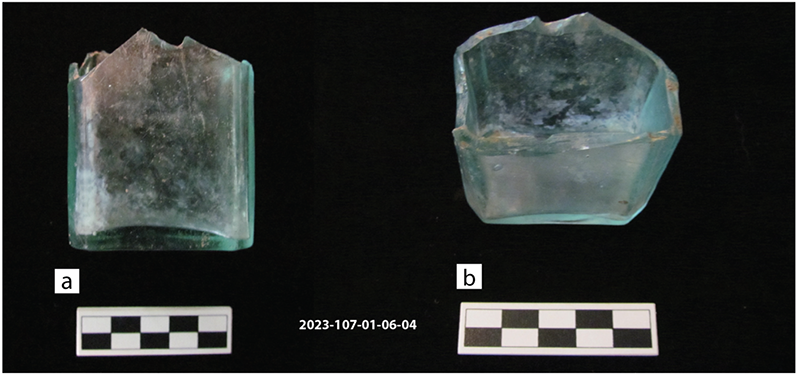
Figure 18. Medicine bottle base from Unit 6. (a) Side view. (b) Top view.
Trench Unit 1 (2023-105)
Trench Unit 1 began as a series of trenches placed behind the Wright House in order to test for architectural evidence of the northern extent (back) of the former St. John’s structure (see Figure 7). Testing in this area was limited by architectural debris from the damaged Wright House, and a general concern for safety from the damaged building. Nonetheless, a series of low- impact, shallow trenches using a Kubota tractor were dug while monitoring for the existence of any buried features (Figure 19a). Very quickly these efforts exposed two large cut stones with evidence of having been quarried, such as a single large stone containing a small dynamite blast hole (Figure 19b). After the two stones were exposed, trenching was halted to establish an excavation trench in order to systematically map and evaluate the extent of the feature.
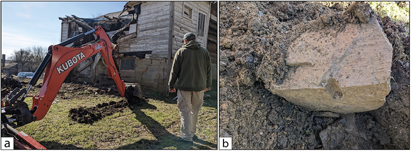
Figure 19. Trench Unit 1. (a) Initial exposure using a Kubota with low-impact trenches. (b) Exposed stone with evidence of having been sourced at a quarry.
A 1.5 x 2 m unit was established in order to test the quarried stones, and to identify the possibility of additional buried features. The quarried stones were assigned as Feature 5 (Figure 20). Level 1 (0-30 cm) was established and exposed additional limestone associated with Feature 5, all of which were resting on a compact clay surface. Artifacts (2023-105-01) from Level 1 include numerous window plate glass fragments (n = 53, 225.02 g) and a significant number of nails (n = 304, 1692.1). In fact, nails recovered from Trench Unit 1, Level 1 represent 32 percent of nails collected from all of the excavation units. Nails recovered include large structural cut nails (2023-105-01-19-01), medium sized cut framing nails (2023-105-01-19- 02), cut finishing nails (2023-105-01-19-03), roofing nails (2023-105-01-19-04), and cut nail spikes (2023-105-01-19-05). The structural (> 4 inch) and medium sized framing (2-4 inches) nails were predominately concentrated in two areas (see Figure 20). Initial interpretations suggest that Feature 5 is the remains of a sub-building structural support pillar (SP2) that was located under the St. John’s building, where nail clusters represent nails that were deposited when the building was razed in the early 1950s. Feature 5 was likely similar to the structural pillar (SP1) located to the east of SP2 at the back of the current Wright House (Figure 21).
Also identified within Trench Unit 1 are two drain or sewer pipes recorded as Feature 6. Drain Pipe 1 is an early segmented cement drain pipe whereas Drain Pipe 2 is a more recent 4” PVC pipe. The presence of two drain pipes in this area corresponds with the location of the kitchen area within the Wright House (see Figure 5) and proposed kitchen/bath house in the former St. John’s building (see Figure 3). Their identification demonstrates continuity between the two structures as it relates to kitchen use areas and necessary water management.
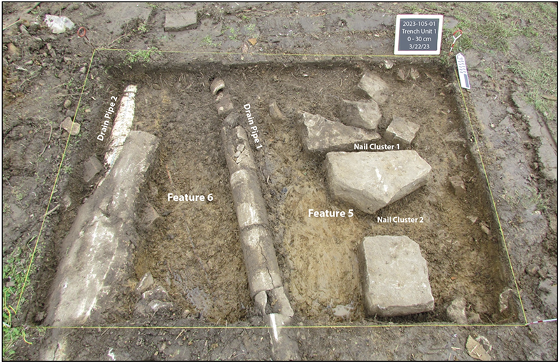
Figure 20. Trench Unit 1, Level 1 showing exposed Features 5 and 6. Note the nail clusters associated with Feature 5.
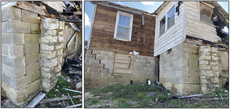
Figure 21. Extant structural limestone pillar (SP1) located to the back of the current Wright House.
SUMMARY AND CONCLUSION
During the week-long field work undertaken at the Wright House, several anomalies and features were identified and interpreted to be associated with the original St. John’s Boarding House formerly located within Block 9, Lots 5 and 6. When data are examined cumulatively, a proposed extent of the structure can be evaluated and modeled for future testing (Figure 22). Features and artifacts excavated from Units 2, 4, and 5 are interpreted as the architectural components associated with the east side of the front porch. Features and artifacts excavated from Unit 3 are interpreted as the architectural remains of the eastern extent of the St. John’s structure, and likely where it turns to the north toward the rear of the structure. Unit 6 identified the partial remains of a brick cistern (CS2), which is interpreted to be situated below the side porch (see also Figure 3). A second structural pillar is interpreted in the location of Trench Unit 1, which likely functioned to support the kitchen/bath vestibule on the west side of the structure. Based on data described in this report, areas of greater confidence regarding the proposed extent of the St. John’s structure are concentrated in the south (front) and east sides (see areas highlighted in green, Figure 22). Areas of less confidence, largely because of time limitations and lack of testing, are concentrated to the west and back of the structure (see areas highlighted in red, Figure 22).
The proposed extent of the St. John’s Boarding House is tentative and will require additional testing better understand the relationship with identified architectural features. However, this preliminary survey and excavation at the Wright House property (Block 9, Lots 5 and 6) has provided an initial understanding of the location and orientation of the St. John’s House that can be utilized for further testing. In particular, additional testing should focus on the presence and integrity of burial architectural features on the west and south (rear) using the proposed extent as a model. Furthermore, the removal of the Wright House superstructure will allow for data collection and mapping of extant St. John’s House architectural features under the Wright House that were incorporated into its construction. With the integration of these two datasets, a clearer picture of the full extent of the St. John’s House can be realized.
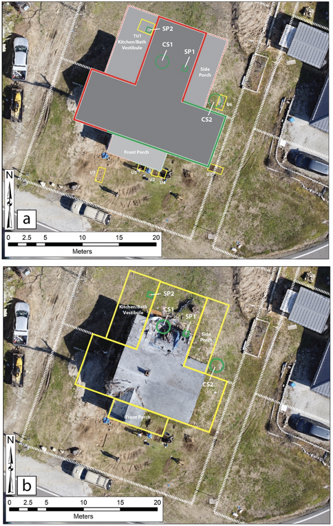
Figure 22. Proposed extent of St. John’s Boarding House. (a) Green are areas of greater confidence, red of lesser confidence. (b) Full outline and relationship to current Wright House and Block 9 property boundaries.
REFERENCES CITED
Adams, William Hampton
2002 Machine Cut Nails and Wire Nails: American Production and Use for Dating 19th-Century and Early-20th-Century Sites. Historical Archaeology 36(4):66-88.
Campana, Stefano
2017 State-of-the-art and Future Perspectives: Drones in Archaeology. Archaeological Prospection 24(5):275-296.
Clark, Anthony
1996 Seeing Beneath the Soil: Prospecting Methods in Archaeology. B. T. Batsford Ltd., London.
Farnsworth, Kenneth B.
2015 Drugstore Bottles for Archaeologists: Embossed Springfield Pharmacy Glassware from
the Civil War to the Roaring Twenties. Illinois State Archaeological Survey Prairie Research Institute, Technical Report No. 165.
Johnson, Jay K. (editor)
2006 Remote Sensing in Archaeology: An Explicitly North American Perspective. University of Alabama Press, Tuscaloosa.
McKinnon, Duncan P., and Bryan S. Haley (editors)
2017 Archaeological Remote Sensing in North America: Innovative Techniques for Anthropological Applications. University of Alabama Press.
Newman, T. Stell
1970 A Dating Key for Post-Eighteenth-Century Bottles. Historical Archaeology 4:70-75.
Roenke, Karl G.
1977 Flat Glass: Its Use as a Dating Tool for Nineteenth Century Archaeological Sites in the Pacific Northwest and Elsewhere. Northwest Anthropological Research Notes 12(2):1-128.
Streeter, Donald
1971 Wrought Iron Hardware for Exterior Shutters. Bulletin of the Association for Preservation Technology 7(1):38-56.
1973 Early American Wrought Iron Hardware: H and HL Hinges, Together with Mention of Dovetails and Cast Iron Butt Hinges. Bulletin of the Association for Preservation Technology 5(1):22-49.
Wells, Tom
1998 Nail Chronology: The Use of Technologically Derived Features. Historical Archaeology 32(2):78-99.