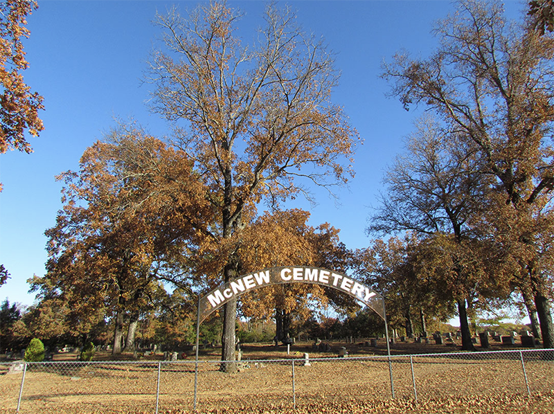
Figure 1. Looking north toward the cemetery signage and fenced burial area.
| Excel Inventory | Feature Forms | Photographs |
Between November 2021 and December 2022, the Jamie C. Brandon Center for Archaeological Research (JCB Center) and Faulkner County Museum conducted a survey and mapping program at the historic McNew Cemetery (3FA347; Figure 1). The cemetery is located less than a mile from Woolly Hollow State Park in what is known as the Centerville Community (see Dolan et al. 1986:290). In 1855, William and Elizabeth McNew and their six children settled on 160 acres of land, and ultimately acquired a significant amount of additional land to become substantial farmers in the area. Oral tradition states that young Valentine McNew, son of William and Elizabeth, died in February 1858, at the age of 9 (b. June 1948). He was carried to a low rise and buried on the McNew property. William McNew later donated the 2.5-acre land to create the cemetery. It is an active cemetery with over 500 individuals interred and several locations reserved. Today, it is managed and maintained by the McNew Cemetery Board.
In discussions with the Cemetery Board, it was understood that a need existed to photograph the current state of stones and features. Part of this need stems from a history of vandalism. In July 2008, around 30 stones were knocked over, damaged, and broken (Figure 2). The vandalism was investigated and a police report was filed, but it was not solved. Young men from the Greenbrier High School football team and their coach volunteered time re-standing fallen stones and documenting those that had been broken and needed repair. As part of this project, a total of 1062 photos were taken of visible burial features.
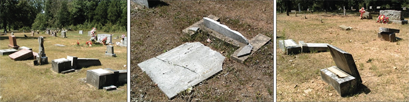
Figure 2. Images documenting vandalism that occurred in July 2008 at McNew Cemetery.
A second need was related to the desire to have an updated inventory and map using a systematic and digital approach. The last map had been made in 1997 and the most recent inventory was dated 2016, which had added to it various hand written notes and comments. The 2016 inventory listed the row and plot designation (A-Z), the name of the deceased (where known) or the name of the reserved plot owner, and whether a grave was unknown unmarked, or no grave allowed. The inventory contains no specific information (birth, death, etc.) on each burial. It was agreed that we would provide a service to the community and Cemetery Board by helping address these needs.
Board and community members provided insight that generated three research questions. The first question relates to the use of electrical resistivity to map the sub-surface and evaluate locations marked as “unknown” burial. Are there resistivity anomalies that likely indicate the presence of unmarked burials in these locations? A second question concerns the possible location of the original chapel and its relationship to contemporary burials. Can the “removal” of later burials (post-chapel) shed light on the position of the chapel? Related, can the stones in an historic (ca. 1917) photo be assigned to current visible stones? The third question is associated with the creation of a Geographic Information System (GIS) database and the availability of KMZ (Google Earth) files to the public. How will the integration of multiple datasets allow for research related to demographics, history, and land use within this space, and to be applied to subsequent cemetery surveys? A discussion of each of these research questions is outlined below.
CEMETERY ORGANIZATION
A low-altitude drone image was collected during leaf-off, which serves as the primary spatial dataset (Figure 3). The drone image was imported into a GIS in order to correlate visible burial features in a high-resolution image with those mapped on the surface using a total station. Visible in the image is a vehicle access path that surrounds the burial area. A local paved road is to the south (McNew Cemetery Road) and curves around the cemetery in the southeast corner. The cemetery is bounded by undeveloped property to the west and north and the gated entrance is to the south.
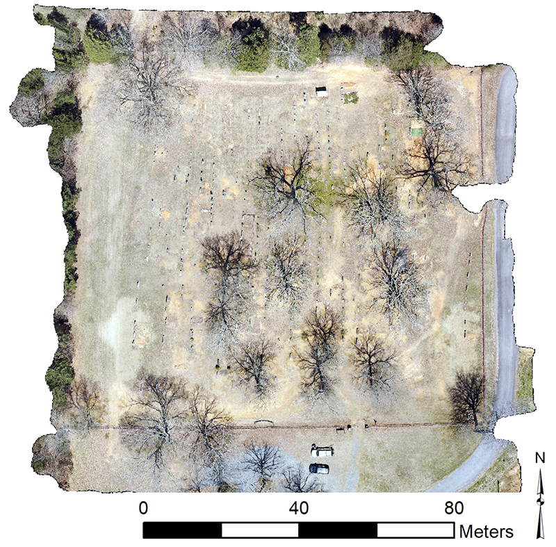
Figure 3. Drone image of the cemetery area taken at an elevation of 200 feet.
Prior to this survey, the McNew Cemetery had previously been organized into 26 rows lettered A-Z and oriented left to right. Numerations within each row begin in the north and move to the south. Some rows contain as many as 60 burials, whereas some contain only a few. The oldest part of the cemetery is the central portion, whereas more recent burials surround the central area. Generally, there are five types of stones: double stones, single upright stones, non-military ground stones, military ground stones, and unmarked sandstones (Figure 4). Some contain dates; some do not.
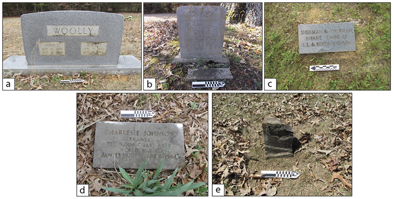
Figure 4. Types of stones prominent at McNew Cemetery include (a) double stones, (b) single upright stones, (c) non-military ground stones, (d) military ground stones, and (e) unmarked sandstones.
RESISTIVITY SURVEY (RESEARCH QUESTION 1)
Our first research question is associated with the use of electrical resistivity to map the sub-surface and evaluate locations marked as “unknown” burial. In short, we were interested in documenting the location of subsurface resistivity anomalies and evaluating their distribution and relationship to areas in which there are no visible surface stones, and may represent an unmarked or unknown burial.
Electrical resistance surveys measure the level of resistance (R) in the subsurface by injecting a current (I) into the ground using a low voltage (V) resistance meter. The ratio of current to voltage defines resistance and is expressed by Ohm’s Law, mathematically stating that R=I/V. While resistance is an electrical quality, resistivity is the actual specific property of the material. Its conversion allows for the “resistance of different materials to be compared in a standardized way” (Clark 1996:27). Electrical resistivity is measured and reported in ohm-meters.
Variations in resistance measurements are based on the principle that geological features hold different materials and different amounts of moisture. Both exhibit varying levels of resistance to an electrical current, and the latter has a particularly large effect in archaeological sites. As a general principle, these varying levels of high resistance (low conductivity) might represent a shallow subsurface of compressed soil matrix, such as a compacted buried surface where porosity is decreased and evaporation is elevated. In contrast, a measurement of low resistance (high conductivity) might represent a pit or depression where moisture has accumulated into a more porous soil matrix (burial void) and is less likely to evaporate–or at least evaporate at a slower rate.
At McNew Cemetery, five 20 x 20-meter grids (65.62 x 65.62 feet) were established in order to encompass most of the fenced cemetery area for a total area of 2000 square meters (0.50 acres; Figure 5a). Electrical resistivity was collected within each 20 x 20-meter grid with spacing between transects (Y) and along the baselines (X) each set to half-meter spacing (1.64 feet). Generally, current (I) ranges were set to 1 mA at an output voltage (V) of 40 V allowing for a resolution of 0.0005 ohms. However, when the ground was particularly dry (summer months) current (I) ranges were set to a maximum of 4 mA. Data were collected zigzag (walking back and forth) using an RM Frobisher TAR-3 Resistance meter (Figure 5b).
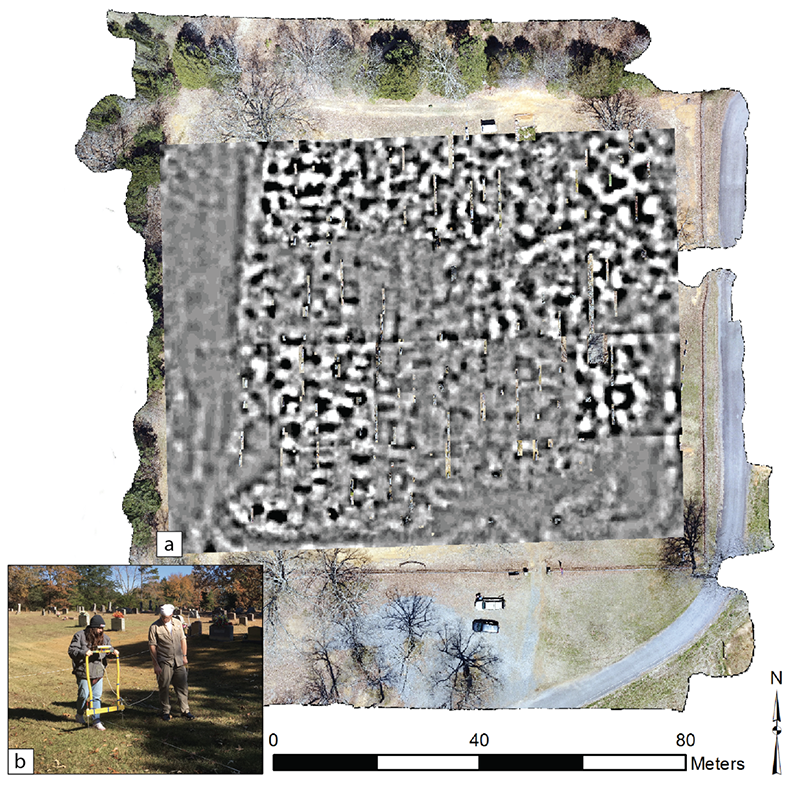
Figure 5. (a) Resistivity data overlain on drone imagery; (b) UCA students collecting data using an RM Frobisher TAR-3 Resistance meter.
Resistivity survey reveals clear patterns that define the relationship of resistance anomalies to visible surface stones associated with more recent burials. For example, Rows D, E, and F contain more recent burials where resistivity anomalies are likely associated with the presence of modern funerary caskets and the use of mechanized means of digging and backfilling (Figure 6). Results reveal several low resistance (high conductivity) responses (black) that represent a burial pit where moisture has accumulated into a more porous soil matrix. In short, compact soil that was removed to dig the burial has been redeposited over a burial casket as a loose soil matrix that is different from the surrounding compact undisturbed soil. Thus, the loose soil matrix has a different rate of water absorption and is more conductive and lower in resistance that the surrounding soil.
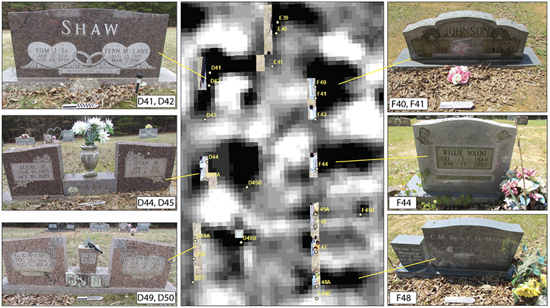
Figure 6. Resistivity results of more recent burials located in Rows D, E, and F. Black anomalies represent low resistance/high conductivity resistivity responses.
In the current inventory managed by the McNew Cemetery Board, numerous locations are marked as unknown with the potential for burials with no stone present. Within the database created for this project, those locations have been recorded with the attribute TYPE as NO_STONE. Using a GIS, NO_STONE locations can be isolated from visible stones and viewed independently (Figure 7). Results reveal several NO_STONE locations spread throughout the cemetery. A few NO_STONE burials are located to the west in Rows C, D, and F and a couple are located to the south in rows K, P, and W. However, the majority of NO_STONE burials are concentrated within two clusters visible in the central and northeast portions. These areas contain some of the earliest burials in the cemetery. Cluster 1 is primarily a row of unmarked burials within Row O (O16-O30) in the central portion, whereas Cluster 2 represents a larger group largely distributed across Rows R, S, T, and V.
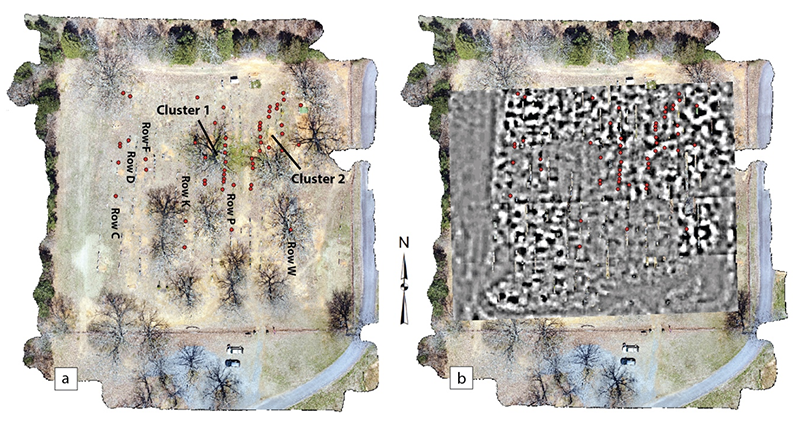
Figure 7. (a) Location of NO_STONE locations forming two cluster areas. (b) No stone areas with resistivity.
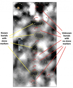
Figure 8. Resistivity results in Cluster 1 along Row O marking the location of known (yellow) and unknown (red) burials.
Resistivity reveals patterns associated with the stones, but anomalies are much more ephemeral than those of more recent burials. This is likely related to early types of funerary caskets, perhaps wood or other perishable material that has long deteriorated where the surrounding soil has become more homogenous with the surrounding soil matrix. Additionally, it is assumed that early burials would have been dug by manual process (shovel) where the boundary between disturbed and undisturbed soil would be less defined. For example, Cluster 1 contains nine NO_STONE types along Row O and alternate fairly regular between burials with visible stones (Figure 8). In many cases, a clear resistivity response pattern defines the outline of a burial, such as O16 and O18. However, most are not defined clearly with distinctive boundaries from the surrounding soil matrix. In some instances (O24, O25, O27) a small resistance anomaly is visible. Perhaps, these represent the burial locations of unnamed infants buried within small caskets.
A similar pattern exists in the Cluster 2 area to the northeast. Burials with visible surface stones are clearly identified in the resistivity data, whereas many of the unmarked NO_STONE locations are much more homogenous to the surrounding soil matrix (Figure 9). In addition, two low resistance anomalies are visible north of Rows R and S that do not correspond to a NO_STONE designation and may represent two undocumented burials in this area. They are in alignment with the Row R known burials and are of similar size when compared to known burials. Additional research is necessary to evaluate if these anomalies are natural, such as the remains of former trees, or if these are indeed undocumented burials.
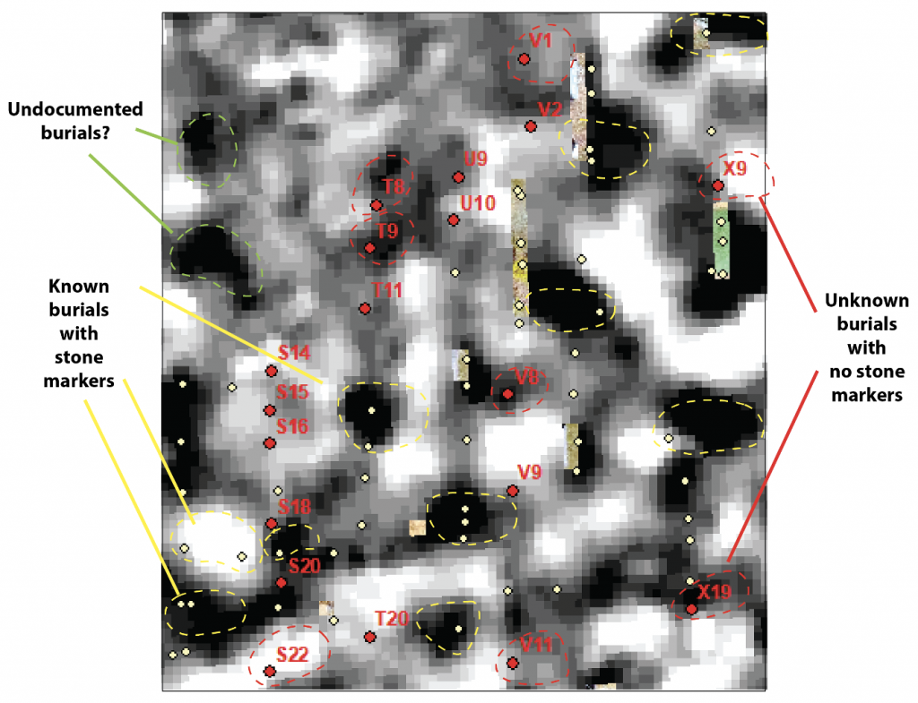
Figure 9. Cluster 2 area in the northeast portion of the cemetery. Burials with no stone markers are identified in red, whereas burials with visible stones are marked in yellow. Two low resistance anomalies are located north of Rows R and S and may represent undocumented burials.
HISTORIC CHAPEL (RESEARCH QUESTION 2)
A second question concerns the possible location of the original chapel and its relationship to contemporary burials. Local lore suggests that the original McNew Chapel was located to the east and was destroyed when a tornado came through the Centerville area around 1920. An historic photo, dated ca. 1917, shows the general location of the chapel in what looks to be slightly downslope from the central high-ground of the original cemetery (Figure 10). A steeple is located on the roof on the gable end to the south. There is a visible door facing west-northwest. A single window is visible. Likely, the chapel was a single room building. Using approximations of the door and window widths (2.5 feet wide), the chapel is estimated to be around 25 to 35 feet in length on the door/window side (west).
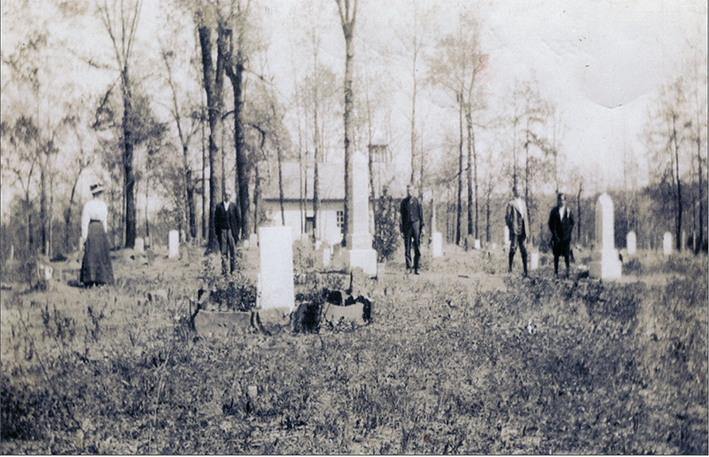
Figure 10. Historic photograph of the McNew Cemetery with the chapel in the background. The photo is estimated to date to April 1917.
A landscape ridge can be seen in the background and represents the current ridge-line running southwest-northeast. Five individuals are standing in pose for the photograph in front of the chapel. Several large cemetery stones are visible with a medium upright stone in the foreground. The medium stone in the foreground has several sandstones resting on their side to form a boundary around the grave. Today, there are no burials that contain a space delineated by sandstones. It is likely they have been moved over the years. In fact, the stones in the photograph are similar in size and shape to many unmarked sandstones that are present at other burials. There are no leaves on the trees and it looks as though the trees are budding.
The occasion of the photograph is open to interpretation, but certainly it marks a specific event given the bulky and expensive nature of photography in the early 20th century. Perhaps, the individuals are attending a graveside service, but there are no visible open burials. It is suggested that the photo was taken in mid-April, perhaps on Easter Sunday after a morning service. This is proposed based on the dress of the individuals, who are wearing nice clothing and with light jackets (such as spring might necessitate) as well as the budding trees.
To evaluate the possible location of the former chapel, a GIS was used to “remove” all burials that post-date April 1917 and to evaluate burial patterns to consider our second research question: Can the removal of later burials (post-chapel) shed light on the position of the chapel? At total of 87 marked burials (where death dates are known) represent individuals that were buried before April 1917 (Figure 11a). The burials are concentrated within the central portion of the cemetery and to the northwestern corner. Based on the presence of the landscape ridge, it is interpreted that the photographer in the historic photo is in the northwest corner of the cemetery and individuals are facing to the west-northwest (Figure 11b).
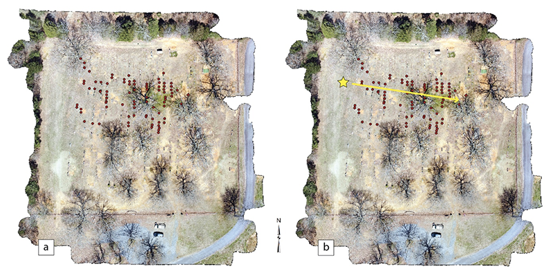
Figure 11. (a) Distribution of pre-April 1917 burials. (b) Proposed location of photographer (yellow star) and direction facing to the east.
A related question concerns the possible identification of stones visible in the 1917 photograph with current visible stones on the surface today. Based on a field evaluation, proposed positioning of the photographer, and a comparison of stones visible in the 1917 photograph with similar styles of stones and placement at the cemetery today, the identification of a several burial locations are proposed (Figure 12). The medium stone in the foreground is interpreted as the location of E15, Artie Woolly (d. 1904), based on its very regular rectangular shape without a curved top. It is the only stone of this shape in this location today. Using E15 to orientate, several additional stones, with their distinctive shape and relative proximity to each other, nicely align with those in the historic photograph. For example, the medium sized obelisk of G21, G.W. Blythe (d. 1909) and the location and distinctive curved shape of K28 (D.A. Henderson, d. 1901) and K29 (M.E. Henderson, D. 1902). Valentine McNew (d. 1858) is located at the highest elevation in the center of the cemetery, as noted in local lore (see above).
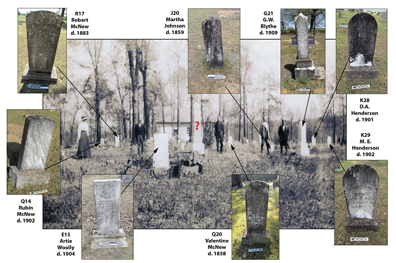
Figure 12. 1917 historic photograph with proposed identification of several stones visible today.
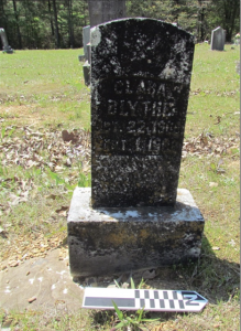
Figure13. G18, Clara Blythe. Notice stone feature visible under the current burial stone.
While most stones provide a nice match with those visible today and those documented in the 1917 photograph, there is a single large obelisk that cannot be placed. It is behind E15 and looks to be located within Row G and a few burial spots north of G21, G.W. Blythe. However, a similar stone does not exist today. The only pre-1917 stones currently visible in this location are those of G17, (an unknown Blythe infant, born and died, July 22, 1900) and G18 (11-month-old Clara Blythe, d. 1906). Two proposed considerations are offered. The first is related to vandalism and the possible removal of the stone in the intervening 115 years. A second is related to the purported tornado that destroyed the chapel building. Such a storm might be forceful enough to have toppled and broken a tall obelisk. Interestingly, the burial of G18 does contain an unusual stone feature that may represent the former base, where a smaller stone might have been erected to replace the damaged stone (Figure 13).
Using these GIS and field-based analyses to identify the likely position of the photographer, evaluate orientation of visible stones in the photograph, and a consideration of landscape features and topography, a proposed location of the former chapel is offered (Figure 14).
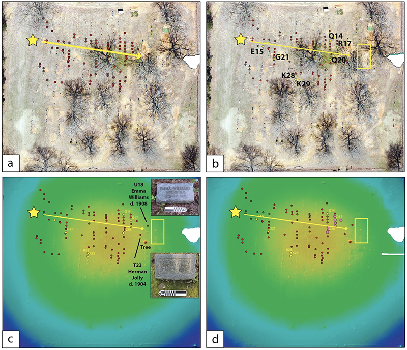
Figure 14. (a) Proposed location of photographer and direction of historic photograph (b) Proposed location of the chapel and its association to identified burials in historic photograph (c) Pre-April 1917 burials overlain on topographic map. Note higher elevation (yellow) and its association with early burials. The chapel is located slightly off slope from the highest elevation (d) Directly east of the chapel location are several early McNew burials that are highlighted in purple.
In the historic photograph, the chapel is situated between R17, Robert McNew, and Q20, Valentine McNew and located off-slope from the low topographic rise that defines the center and oldest part of the cemetery (see Figure 12). Using the proposed positioning of the photographer, in addition to the topographic landscape, the chapel is interpreted as having been located to the west of what is today Row U. Two burials (U18 and T23) are located directly in front of the chapel and today are documented with replacement ground stones (see Figure 14c). Additionally, all of the pre-April 1917 McNew burials (n=8) are located directly to the east of the chapel (see Figure 14d; Table 1). This includes three infants Ider (R18), Yelma (R19), Jonathan (S19), and, as already mentioned, Valentine McNew (Q20) who is the first buried in the cemetery. Anecdotal descriptions, acquired from Dr. Ben McNew, state that the Valentine McNew burial was located directly outside the entrance to the chapel.
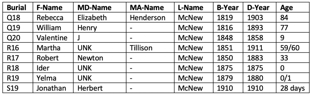
Table 1. Pre-April 1917 McNew burials.
GIS DATASET INTEGRATION (RESEARCH QUESTION 3)
The third research question is associated with the creation of a GIS database and the availability of KMZ (Google Earth) files to the public. In short, how will the integration of multiple datasets allow for research related to demographics, history, and land use within this space, and to be applied to subsequent cemetery surveys? The value of a GIS is the ability to query attribute data in order to evaluate trends, common themes, and outliers within multiple datasets linked together in a relational database. These data can be exported into a KMZ file, which allows for the availability to the general public without the need for GIS software or processing experience. A KMZ file can be loaded into Google Earth and searched in a similar manner.
The previous discussions demonstrate the value of integrated datasets (resistivity, drone imagery, elevation data, burial information) within a GIS in order to address specific spatial questions and analyze various relationships across a landscape. In addition to spatial questions, interesting queries can be generated that pertain to demographic information, genealogical research, and community life histories. For example, attributes for each stone were collected in the field regarding military history and service as they are listed on each stone. According to the information gathered from burials stones, at least 50 individuals buried at McNew were in the service and are buried throughout the cemetery (Figure 15a). Many of these individuals are recognized for their service with a formalized military stone (MIL_STONE), which is often located at the foot of the burial opposite a headstone. These are often flat markers in granite, marble, or bronze and are available from the Department of Veterans Affairs (VA) at no cost to the deceased family, although the family is required for any costs associated with installation.
Often military stones notate the military branch. At McNew Cemetery, all branches are recognized and include Army, Navy, Air Force, and Marines. There are also stones that indicate individuals who fought in the US Civil War. VA military stones may also indicate rank, such as the stone of George Eugene Wise (B15), which indicates his rank in the Navy was FN (Fireman)—an enlisted rank in the US Navy engaged in the operation of marine engineering machinery (Figure 15b). Or, George W. Cates, which indicates his service in the Air Force as SSGT (Staff Sergeant)—a noncommissioned rank in the Air Force that is above senior airman and below technical sergeant—and also served in the Navy (Figure 15c).
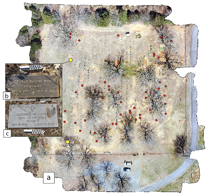
Figure 15. (a) Distribution of military stones indicating individuals who served in a military capacity. (b) George Eugene Wise, FN US Navy (c) George W. Cates, SSGT US Air Force and US Navy.
Of the 50 identified individuals 38 (76 percent) served during active combat, including four who served during the US Civil War (Figure 16). Fifty percent of the veterans buried at McNew served during World War II (WWII), which lasted from 1939 to 1945 where United States involvement lasted from 1941 to 1945. Three Purple Heart Medal recipients, an award provided by the President of the United States to those killed or wounded in battle, are buried in McNew. One Purple Heart recipient was also awarded the Bronze Star Medal–an award given for heroic or meritorious service or achievement in a combat zone. Three individuals likely died in combat, as their death dates coincide with dates of conflict (Table 2).
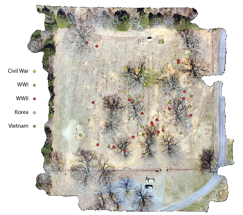
Figure 16. Distribution of individuals who fought in active conflicts.
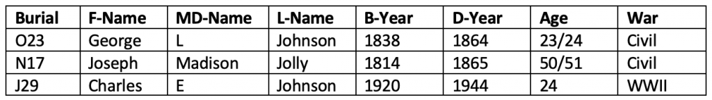
Table 2. Individuals who likely died during conflict.
CONCLUSION
Over the course of a year, the McNew Cemetery was mapped and documented in order to provide an update to the McNew Cemetery Board and evaluate three primary research questions. Results demonstrate the value of a systematic cemetery recording project and how data can be utilized to consider spatial, temporal, and genealogical questions to a multitude of interested individuals and researchers. The methods associated with the collection and integration of these data will be used as a model for further cemetery documentation throughout Faulkner County.
Data are integrated using ArcGIS 10 and exported to a KMZ file that can be opened using Google Earth or ArcGIS Earth. The KMZ file can be downloaded here.
REFERENCES
Clark, Anthony
1996 Seeing Beneath the Soil: Prospecting Methods in Archaeology (New Edition). Revised Edition. B. T. Batsford Ltd., London
Dolan, Doris B., Hattie Ann Kelso, and Corinne H. Robinson
1986 Faulkner County: It’s Land and People. Faulkner County Historical Society.