
Figure 1. Looking south across the adjoining pasture. Cemetery is located directly to the east behind the tree line.
| Feature Forms | Photographs |
On May 23, 2023, the Jamie C. Brandon Center for Archaeological Research (JCB Center), Faulkner County Museum (FCM), and University of Central Arkansas (UCA) students conducted a one-day survey and mapping program at the Royster-Cross historic cemetery in northern Faulkner County (3FA349; Figure 1). The cemetery had not been previously recorded and the work was undertaken as part of the annual UCA archaeology field school. The work is also part of the ongoing Faulkner County Survey Project (FCSP), which seeks to map and document historical and archaeological resources in Faulkner County (McKinnon and Langley-Ware 2017; see Dolan et al. 1986).
The cemetery contains several stones containing no markings or indications of individuals. It is located eight miles east of Greenbrier on land that was originally surveyed in 1819 and 1820 and later patented to David Royster on April 15, 1837 by U.S. President Martin Van Buren (Figure 2). The patent lists the land as located in the “Northwest fractional quarter of fractional Section eighteen, in Township seven North, of Range twelve West, in the District of Lands, subject to sale at Little Rock, Arkansas, containing one hundred and thirty five acres and ninety three hundredths of an acre [135.93 acres]” (Van Buren 1837).
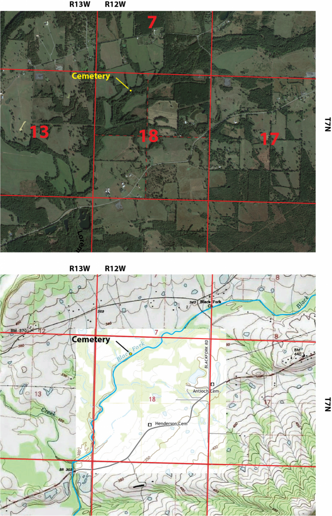
Figure 2. Location of the Royston/Cross Cemetery.
Black Fork Creek is directly to the south of the cemetery and where the landform drops significantly to the creek bed (Figure 3). The cemetery is in a heavily overgrown area and not visible from the adjoining pasture, although it is only around 20 feet within the tree line. A large soil ridge or berm about two feet in height bounds the cemetery on the west and north (see Figure 3). The soil ridge was not tested, and only followed for a few meters beyond the survey area as it follows along Black Fork Creek. It could represent a constructed low-height levee to protect the adjoining pasture or naturally deposited from water lain flood deposits. Current landowners stated that this area floods regularly during wet seasons.
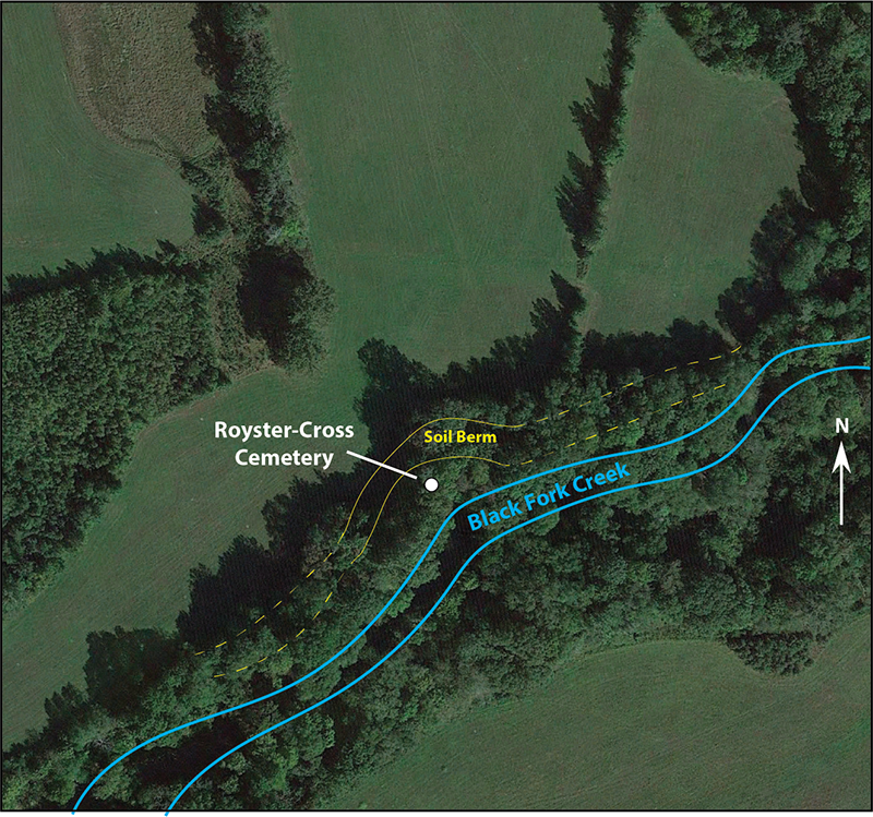
Figure 3. Landforms surrounding the Cemetery. Note the soil berm.
PROPERTY OWNERSHIP HISTORY
Property abstracts state that David Royster and his wife Elizabeth sold the land to William Wiley Sr. in 1840. Apparently, Wiley did not pay taxes on the land and it was forfeited in 1848 to the Conway County tax collector (prior to the establishment of Faulkner County). The county then sold it to Benjamin Murphy, presumably for the cost of the overdue tax amount. Benjamin Murphy turned around that same year and sold it to his son, Benjamin Murphy, Jr. In 1859, the descendants of William Wiley Sr. filed for a partition of the lands claiming that Mr. Wiley had died, and that the land had been improperly seized. The court ruled that there were too many descendants and that the land was not profitable. Therefore, it was ordered to be sold with the proceeds divided among the Wiley family.
Richard Dickens purchased the property in 1859 from the state of Arkansas, and in 1861 Richard and his wife Jane filed a Quit Claim on the land to Paschal Dickens. Paschal sold the land in 1873 to John Belote. Between 1894 and 1898 John Belote and his wife Elizabeth mortgage the property three times, each time satisfying the mortgage. However, Elizabeth dies in 1898 and John Belote sells the property to Joseph May. In all there were over 300 acres. From this point the land is referred to as the May Farm in property abstracts.
Interestingly, a small 1.5-acre parcel of the land described in property abstracts, and located near the creek, was seized in 1881 by the state for non-payment of taxes. The property was tied up in court between 1881 and 1884 and in 1884 eventually sold to the state by Faulkner County for the taxes owed. While it is uncertain, and there is no mention made of a burying ground in property abstracts, the 1.5-acre parcel is in approximately the right location of the Royster-Cross cemetery documented during this fieldwork.
Times were hard all over. Between 1899 and 1902 Joseph and wife Mary May mortgage the land three times, each time satisfying the mortgage and retaining ownership. Between 1919 and 1932 the May Farm underwent more financial difficulty, with parcels being sold to the state for the nonpayment of taxes. Joseph sold the property to Frank Farris in 1929, and then died at some point. The heirs of the Joe May estate held up the property in court between 1932 and 1936 with a complaint in equity. During this time, the property was sold to the state for nonpayment of taxes, ordered to be surveyed for sale by Herman Stermer, the Faulkner County Surveyor, sent into a receivership, and finally sold on the east steps of the Faulkner County courthouse to Dibrell (Dib) Williams in 1937 for $1275.00. For several years prior to the sale of the land on the courthouse steps, Dibrell and his father Dr. Earl T. (Doc) Williams were engaged in purchasing interests in the May Farm owned by numerous heirs. Dib Williams played baseball for the Little Rock Travelers, and eventually signed with the Philadelphia Athletics in 1930, playing in the World Series in 1931. He left the Majors around 1936, but continued to play on minor league teams for another decade. It is likely that he purchased the farm with earnings from his baseball career.
In 1952, Dibrell and his wife Geneva sold the land to Karl and Mary Schmidt, who retained the property until 1966. In 1966, Karl and Mary sold the property to Herbert and Russell Cross. The Cross family has owned the property since 1966.
CURRENT FIELDWORK
For this project, field work consisted of clearing and identifying surface features, collecting subsurface electrical resistivity data, feature mapping, and collection of low-altitude drone imagery. After clearing a small area (12m x 8m), visible stones were organized into four burial rows (A-D) with burials oriented east-west (Figure 4a). Sixteen visible sandstone markers were documented. Headstone and footstone markers are positioned upright, but contain no markings or inscriptions. Many stones have been partially (or mostly) buried by flood deposits (Figure 4b). A single burial (A4) contains a visible surface stone that probably represents a coverstone (Figure 4c). Two burials (C1, D1) have flat stones that are buried just below the surface and may represent coverstones, or fallen headstone or footstones (Figure 4d). Additional coverstones are also likely present with other burials based on preliminary probing with chaining pins. Also documented are three surface depressions indicative of unmarked burials (A3, B2, C3). The surface depressions align with marked burials and are recorded as possible burial locations. Taken as whole, thirteen possible burials were documented within the survey area. Based on spacing between visible headstone to footstones, many of the burials likely represent infant or adolescent individuals. Additional stones may be present outside the survey area in the leaf litter, buried beneath water lain deposits, or as unmarked burial depressions.
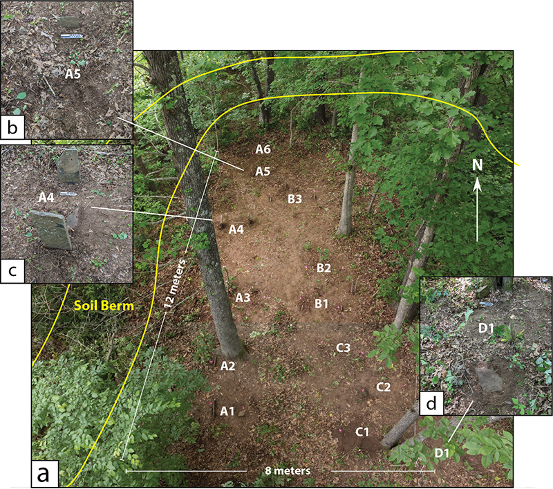
Figure 4. Drone image of the cemetery showing (a) cleared survey area containing (b) buried stones, (c) burials with coverstones, and (d) burials with stones level with the surface.
In addition to the clearing and mapping, an electrical resistivity survey was conducted within the survey area. Electrical resistance surveys measure the level of resistance (R) in the subsurface by injecting a current (I) into the ground using a low voltage (V) resistance meter. The ratio of current to voltage defines resistance and is expressed by Ohm’s Law, mathematically stating that R=I/V. While resistance is an electrical quality, resistivity is the actual specific property of the material. Its conversion allows for the “resistance of different materials to be compared in a standardized way” (Clark 1996:27). Electrical resistivity is measured and reported in ohm-meters.
Variations in resistance measurements are based on the principle that geological features hold different materials and different amounts of moisture. Both exhibit varying levels of resistance to an electrical current, and the latter has a particularly large effect in archaeological sites. As a general principle, these varying levels of high resistance (low conductivity) might represent a shallow subsurface of compressed soil matrix, such as a compacted buried surface where porosity is decreased and evaporation is elevated. In contrast, a measurement of low resistance (high conductivity) might represent a pit or depression where moisture has accumulated into a more porous soil matrix (burial void) and is less likely to evaporate–or at least evaporate at a slower rate.
At the Royster-Cross Cemetery, a single 12 x 8-meter grid was established in order to encompass the cleared area (Figure 5a). Electrical resistivity was collected with spacing between transects (Y) and along the baselines (X) each set to half-meter spacing. Current (I) ranges were set to 1 mA at an output voltage (V) of 40 V allowing for a resolution of 0.0005 ohms. Data were collected zigzag (walking back and forth) using an RM Frobisher TAR-3 Resistance meter (Figure 5b).
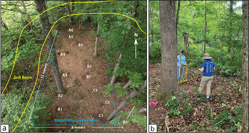
Figure 5. (a) Electrical resistivity survey area. (b) Students collecting resistivity data in the cleared area.
Results reveal several low resistance (high conductivity) responses (white) that correspond to marked surface stones. These locations likely represent a burial pit where moisture has accumulated into a more porous soil matrix. In short, compact soil that was removed to dig the burial has been redeposited over the burial as a loose soil matrix that is different from the surrounding compact undisturbed soil. Thus, the loose soil matrix has a different rate of water absorption and is more conductive and lower in resistance that the surrounding soil. Three burials (A1, A4, and B1) have responses (black) that are high in resistance (low conductivity). Initial probing suggests these contain stone covers, which would impact changes in moisture absorption and resistivity responses.
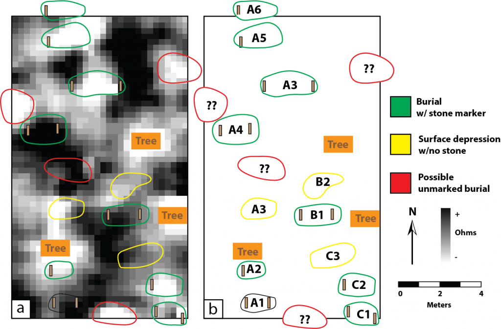
Figure 6. (a) Electrical resistivity survey results with (b) interpretation.
Additional stones and burials may be present outside the survey area in the leaf litter, buried beneath water lain deposits, or as unmarked burial depressions. Given the complicated property ownership history, it is not known if these burials represent members of the original Royster family settlers or a later family. It is referred to as the Royster-Cross cemetery by utilizing the first and current owner surnames of the property. When the Cross family purchased the property in 1966, the cemetery had been abandoned by then. A detailed review of property abstracts was conducted for this research, and while undiscovered family documents may reveal who is buried at the cemetery, at present, no definitive local knowledge remains.
CONCLUSION
Over the course of a single day, the Royster-Cross cemetery was cleared, mapped, and documented in order to provide information to the current property owners, as well as providing UCA students an opportunity to apply archaeological method to an historic cemetery.
REFERENCES
Clark, Anthony
1996 Seeing Beneath the Soil: Prospecting Methods in Archaeology. Revised Edition. B. T. Batsford Ltd., London
Dolan, Doris B., Hattie Ann Kelso, and Corinne H. Robinson
1986 Faulkner County: It’s Land and People. Faulkner County Historical Society.
McKinnon, Duncan P., and Lynita Langley-Ware
2017 The Faulkner County Survey Project: Mapping, Evaluating, and Documenting Historical and Archaeological Resources. Journal of Undergraduate Research in Anthropology 1:3-7.