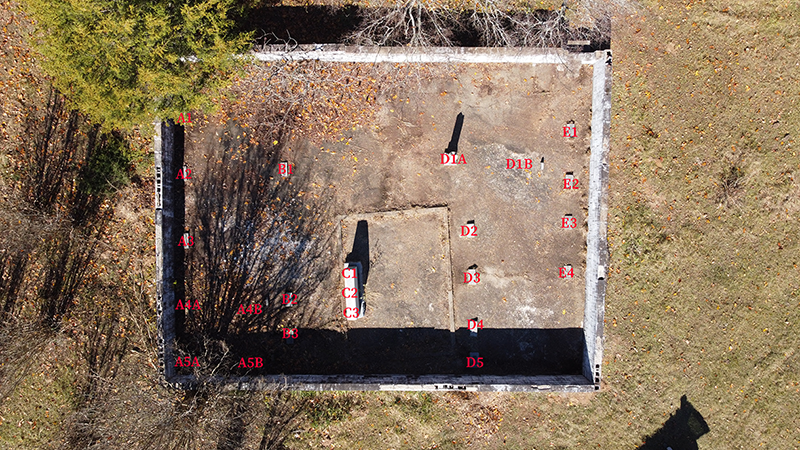
Figure 1. Drone view of Woolley Cemetery looking to the west.
| Excel Inventory | Feature Forms | Photographs |
On November 19, 2021, the Jamie C. Brandon Center for Archeological Research (JCB Center) and the Faulkner County Museum conducted a documentation and mapping program at the historic Woolly (Woolley) Cemetery (3FA346) located about a mile south of the entrance to Woolly Hollow State Park on Arkansas Hwy. 285 (Figures 1 and 2). The purpose of the fieldwork was to clean the cemetery from overgrown brush and debris, and to map, photograph, and document the visible cemetery stones and markers.
In order to protect the cemetery, a cemetery wall of cinderblocks stacked 5 high and capped by 16 x 8 x 2 flat cinderblocks has been constructed around the perimeter. The wall still stands today, although many of the capped cinderblocks have been damaged. The interior of the wall–the actual cemetery space–has been covered with poured cement. The current landscape surrounding the cemetery is a cow pasture with rolling hills and natural, as well as, human-made terraces constructed by Camp Halsey (3FA313) enrollees. A few hundred meters to the southeast is the former the location of the Martin Alfred Woolly (son of William Riley Woolley and Sarah Downing Woolley) homestead cabin (3FA220), which has been moved to and restored at Woolly Hollow State Park.

Figure 2. Left, Dr. McKinnon documenting the epitaph on the W. L. Woolley (D1A) stone as the sun casts a shadow to make it visible. Right, Lynita Langley-Ware records additional details of the stone.
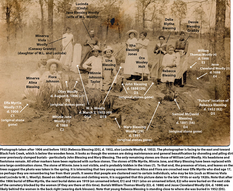
Buried in the cemetery are twenty individuals and represent some of the earliest pioneer settlers to northern Faulkner county, including William Riley Woolley, the first person buried at the cemetery and patriarch of the Woolley family (Figure 3). William Riley Woolly and his wife, Sarah Downing, along with seven of their nine children moved westward from Wayne County, Tennessee. They ultimately settled among the rolling hills along Black Fork Creek in what was to become Centerville in northern Faulkner County. Their last two children, twins William Levi and Martin Alfred, were born in at the homestead in Centerville.

Figure 3. William Riley Woolley (ca. 1812-1859)
CEMETERY ORGANIZATION
The Woolley Cemetery is organized into several north-south rows of visible surface stone features that mark the burial locations of at least 20 interred individuals (Figure 4). As part of this mapping project, rows were numerated into five rows beginning in the northwest corner and moving eastward. Surface stones located within each row were assigned a feature number beginning in the north and moving south. A total of 21 visible features were recorded during the survey. These include vertical and horizontal (on the ground surface) headstones, and a few small footstones. A marked space delineates the largest stone at the cemetery (R3F1) and the burial location of Effie Myrtle, Minnie Jane, and Mary Blessing Woolley.

Figure 4. Location of cemetery features organized into five rows.
The oldest person buried at the cemetery is Rebecca (Sis) Blessing who was aged 82. Of the twenty individuals, nine (45 percent) are children or infants under the age of three. There is a single teenager (Effie Myrtle, aged 17) and three individuals in their 40s. Sarah Downing, wife of William Riley, lived to be 70–23 years past her husband’s death.
Three individuals were in their 20s, including Mary Blessing (wife of Martin Alfred) who died of typhoid fever when their children were young. After the passing of his wife, Martin moved away from the area and is not buried at the Woolley Cemetery. Some of the individuals have been identified in a short genealogy that was provided by Mr. Jerry Blessing.

Data are integrated using ArcGIS 10 and exported to a KMZ file that can be opened using Google Earth or ArcGIS Earth. The KMZ file can be downloaded here.
For more information:
Faulkner County Historical Society
1986 Faulkner County: Its Land and People.
