Camp Halsey in Centerville, Arkansas was the first Soil Conservation Service camp in Arkansas where young enrollees spent their time learning skills to help prepare them for the next stages in their lives. Camp Halsey was occupied about two and a half years by two different companies (1706 and 4748) and under two different and distinct projects (SCS-1 and P-75). Over the course of five years, UCA field school students had the opportunity of doing and learning about archaeology while they map, excavate, and document the CCC occupations at Camp Halsey. With a pedagogical framework and emphasis on using archaeology to develop long-standing skillsets, the UCA field school sought to expand and evolve from the 1930s CCC experience of those first enrollees. What follows is a year-by-year summary of the work undertaken at Camp Halsey between 2018 and 2023. A complete analysis of the Camp Halsey work is available within the Arkansas Archeological Survey Research Publication Series, The Civilian Conservation Corps in Arkansas: From Active Camps to Archaeological Landscapes (2026).
Field Work, May 14-25, 2018

After a hot and humid week filled with a bed of poison ivy (our workspace) and hundreds (thousands?) of ticks, we have successfully completed the scheduled field work associated with the first Field Archaeology (ANTH 4480) field school at UCA!
What began as an inquiry into what was thought to be a possible infirmary (Feature 10), evolved into the realization that Feature 10 was an architectural space related to automotive maintenance and perhaps storage. Rather than a hospital, the space was likely the Army Garage (building #19), which is recorded on the Historical Record of CCC Camp Buildings present at Camp Halsey between September 1934 and November 18, 1938. During the 2018 excavations numerous automotive related items were collected, such as window glass, door (car or building?) hinges, motor parts, wiring, and nuts and bolts. We also documented architectural related items – most notably nails. The only personal item recognized in the field was a very small glass piece of a patent medicine bottle. We will be cleaning, cataloging, and analyzing the artifacts in the UCA Archaeology lab next week.
While artifacts suggest the former structure is the likely remains of an automotive garage, questions remain. For example, the footprint of Feature 10 is roughly 23 x 48 feet, which does not directly match any of the dimensions recorded on the Historical Record of CCC Camp Buildings. In fact, the Army Garage (#19) is listed twice and with different dimensions. The Historical Record also states that the Army Garage was razed in October 1937 and converted into a blacksmith shop (building #26). We found no evidence of smithing in Feature 10, although overgrowth prevented complete excavation during this first season.
Approximately 60-70 percent of Feature 10 was exposed, which is composed of hand mixed, poured, and spread cement that was mixed with local shale and sandstone. The poured areas are 8-feet wide and span the width of structure (approx. 23 feet). Interestingly, a broken glass bottle top was part of the cement mixture and metal detector surveys over both cleared and uncleared floor areas suggest that metal parts are also part of the cement mixture. This suggests that perhaps small bits of trash were also used (at least in small amounts) in the cement fill. It’s not known if that was purposeful or if the trash items are inadvertent inclusions.

Glass bottle top embedded within the cement floor.
Two excavation units were opened adjacent to Feature 10 in areas interpreted as egresses. Unit 1 was established within the proposed Feature 10 main entrance. At this location (SE Corner) two large cement blocks (made with much more dense cement) were present on the inside and outside (FSN 2018-053-03) of the knee-high wall (which was also poured with the same cement mix as the floor). They were likely stepping platforms or stoops to step up and over the knee-high wall. Artifacts from Unit 1 were meager and small (small pieces of glass, some nails, and small bits of metal), which suggests an area regularly cleaned and with a fair amount of foot traffic (hence the small broken bits). A second unit (Unit 2) was established in what was proposed as a back entrance or exit (NE Corner). The Unit 2 location differs in that a cement stepping platform or stoop was not present on the outside of the structure. The eastern half of Unit 2 likely represents a midden area situated immediately outside the back door. The concentrations of artifacts on the eastern (right side) of Unit 2 is likely the result of right-handed technicians opening the back door (which would swing to the left) and tossing unneeded parts into a pile. Excavations were limited because of the significant amount of root growth (both cedar/juniper but also tons of poison ivy!). Nonetheless, numerous artifacts were uncovered, such a large pieces of car window class and automotive parts. A complete map of Feature 10 was created that will be overlain with other data sets (such as total station points) and used to evaluate densities of artifacts and interpretation of the use of space.
In addition to the excavation of Feature 10, magnetic gradiometry, total station, and shovel test data were also collected. Students were exposed to the use of magnetic gradiometry and how to lay out a site-wide grid using a total station (on loan from the Arkansas Archeological Society) A total of 8 20 x 20 meter magnetic gradiometry grids were collected across the former Front Street and the open field to the south. Numerous magnetic anomalies, as anticipated, were discovered. To test some of the magnetic anomalies, a small number (n=6) of shovel tests were done across the former Front Street. While no artifacts were found, shovel tests provide insights into stratigraphy related to the road construction and maintenance.
Overall, the field school was a success. Students gained experience in collecting archaeological data using several different methods. They were exposed to archaeological methods that included remote sensing, site-wide mapping, shovel testing, feature mapping, excavation, and field documentation. In doing so, they all contributed to an ongoing broader project to evaluate Faulkner County historical and archaeological resources and participate in the first set of research and data collection at Camp Halsey. After site data collection was complete, The Halsey’s, who live on the property and graciously allowed us to conduct work at Camp Halsey, cooked the field team a picnic lunch on Friday afternoon. We all sat in the shade on the newly cleaned auto shop floor – a space that hadn’t been used by people in almost 80 years – and discussed what we had learned, the types of artifacts collected, and the shared experience in the 2018 field work.

Group shot on the final day.
Field Work, May 13-24, 2019

After a very productive two-weeks playing in the dirt and tallying tick totals, we have completed the second season of the UCA Field Archaeology course!
We now know that the Army Garage, Building 19 (Feature 10) was razed October 1937 and converted into a Blacksmith shop, Building 26. Building 19 is visible in the Feb. 1937 aerial image. Only the slab, first recorded during the 2018 field school, is visible in the September 1940 aerial image. There is no evidence of blacksmithing in the remaining Building 19 slab, so it is presumed that the frame of the building was converted into a Blacksmith shop and rebuilt elsewhere at the camp. One possibility is the small square slab south of the Building 19 visible in the September 1940 aerial.
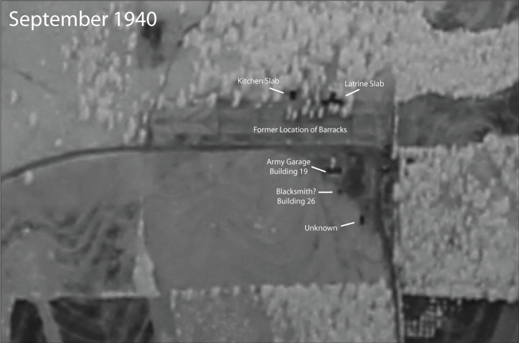
September 1940 aerial image taken after Camp Halsey buildings had been removed. Remaining slabs are visible on those buildings that contained poured concrete. Vegetation “stains” or patterns are visible in the area of the former barracks.
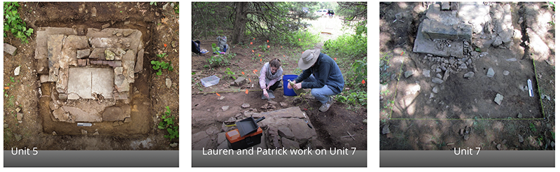
Half way through the field school, excavations began at the possible location of the officer’s quarters (Feature 11). The 1934 inventory of buildings lists “Qtrs for Officers w/screen porch” as a rigid frame structure with five rooms and a capacity of four individuals. Two units were opened. One unit (Unit 6) was opened at the edge of the remaining porch slab to understand the position of the front door of the screened porch. A second unit (Unit 5) was established around the chimney base to evaluate its construction technique.
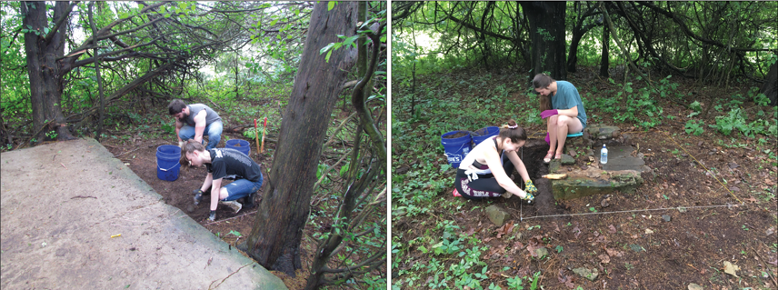
Left, James Dubose and Jordan Cooper excavate Unit 6 at the edge of the patio slab. Right, Breck Brammer and Tiffany Tanksley work on exposing the chimney base in Unit 5.
Excavation at the edge of the patio slab revealed a series of flat stones that likely represent a constructed landing associated with the front door. A large door spring was found in this unit also demonstrating this was the location of the entrance door. A large cedar tree limited further exposure of the constructed landing, although it is hoped that future excavations will allow for a better idea of the size and extent of the stone landing.

Unit 6 and the flat stones that formed a landing for the patio entrance.
The Unit 5 chimney base was also productive by exposing the remaining chimney to evaluate the extent and construction style. A large foundation was constructed under the floor of the house with the chimney built on this foundation. Two large flat stones were centrally placed to form the base of the hearth with large rectangular stones situated around the hearth. Smaller stones were used to create the chimney stack, which has since collapsed with the chimney fall spread to the west (away from the building location).

The exposed chimney base in Unit 5.
Artifacts found within the hearth include broken glass, nails, and other construction debris. One of the more interesting objects (a highlight of the field season!) is a 10 cent CCC camp token that was found in the fireplace hearth. CCC camp tokens were generally issued in 5 cent and 10 cent denominations to camp enrollees. Coins were made by several camps and labeled with the Company number and location. The token that was found is a 10 cent token with the label CO 1706. Company 1706 is first associated as a forestry camp, of which men transferred from Camp Victor to establish Soil Conservation Service 1 – the first Soil Conservation Service camp in Arkansas – on October 1, 1934. Company 1706 occupied Camp Halsey until November 1, 1935.
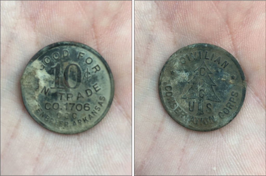
10 Cent CO. 1706 CCC Camp token found in the chimney hearth.
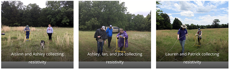
In addition to excavations, testing was also done to evaluate the former location of the enrollee barracks. Resistivity data were collected using a RM Frobisher TAR-3 resistivity meter. Data were overlain on 1937 aerials to evaluate geophysical feature relationships to building locations.
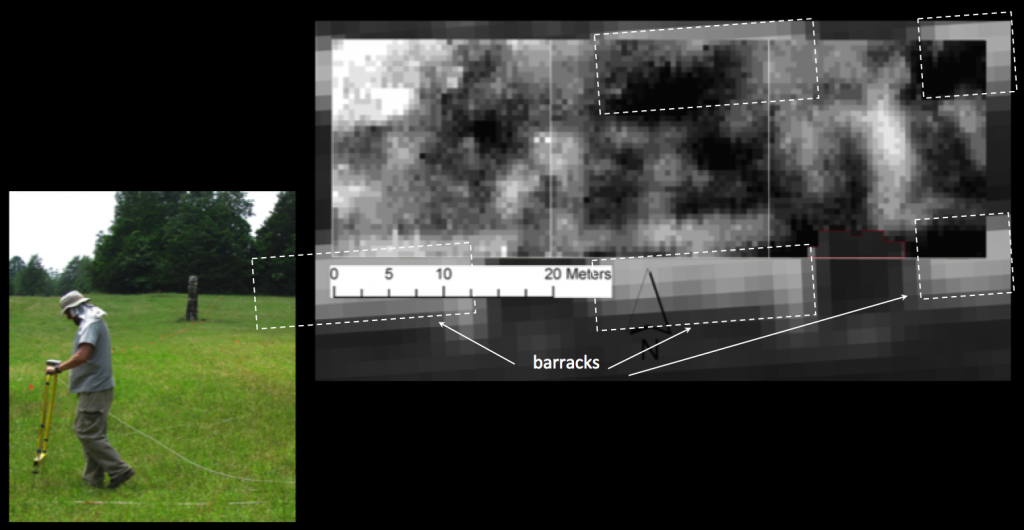
Results from resistivity data collected in the location of the former barracks.
Using these data, 35 shovel tests were dug using a spacing of every 5m and dug at a depth of 35cm and an approximate width of 25cm. Artifacts collected include nails, window glass, and construction debris related to the barracks. The shovel test exercise provided insight into the amount of remaining artifacts and their distribution across the landscape.
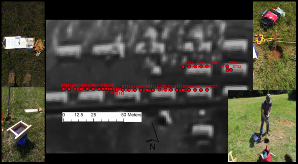
Location of shovel tests dug by Jacob Madle over the course of two weeks.
The 2019 fieldwork was very productive and students had the opportunity to be exposed to a multi-disciplinary approach to address specific research questions related to social, historical, economic, and political aspects of the camp. Several types of data were collected, which include resistivity data, shovel test data, and feature excavations and their associated artifacts.
The students contributed to a broader project to evaluate Faulkner County historical and archaeological resources and participate in the ongoing research and data collection at Camp Halsey. At the end of the field season, the Halsey’s cooked the field team a picnic lunch where we reminisced about the experience, the heat, the ticks, the interesting artifacts found, the questions we answered, and the questions we created to be explored in future field seasons.

Group shot on the final day.
Field Work 2021, May 10-28, 2021

The 2021 UCA Field Archaeology course has officially concluded! After being forced to cancel the 2020 field season, it was very rewarding to be doing research at Camp Halsey again with UCA students. We had a great group this year, and everyone was very productive with new insights gathered using a variety of data collection techniques. And, it rained a lot!
Excavations were resumed at Architectural Feature 11 (AF11), the location of the officer’s quarters. Students cleaned Unit 5 (begun in 2019) in preparation for a new photograph using a drone. After finishing Unit 5, an additional unit was established (Unit 7) to the south of Unit 5 to better understand the chimney foundation construction and process of demolition. Excavations revealed a large ash concentration, along with a large “gate hook” suggesting the presence of an ash removal door on the south side of the chimney.
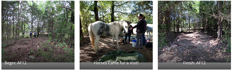
Efforts were also focused on exposing several additional architectural features. Architectural Feature 12 (AF12) was our initial target in order to understand its role in the camp. Students spent several days exposing the feature (with very little artifacts!) and it has been interpreted as the Auxiliary Supply location (Building # 33), listed in the 1934 inventory of buildings as a portable (tent) building that was using during the second occupation of the camp (P-75 Company 4748). In fact, Building 33 is the only building listed as portable rather than rigid in construction. Cement had been poured within stacked stone sides, and with a fairly decent slope to the south. The few artifacts found were all located at the south end of the feature, presumably deposited there as a result of water runoff.
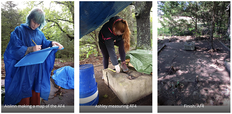
Another architectural feature (AF4) exposed is a pump house located to the north of the camp. The 1934 inventory of buildings lists two pump houses: Pump House #1 (Building 20) at 8 x 8 ft and Pump House #2 (Building 23) at 8 x 12 ft. Based on dimensions, AF4 is likely Pump House #2 and provided water to several buildings, such as the latrine, kitchen, and hospital – all located in close proximity to Pump House #2.
We also returned to Architectural Feature 1 (AF1; Building 18) to explore the outside hearth of the standing chimney. Students exposed a large stone apron that defined a large area outside the chimney and continued inside to form the base of the hearth. This feature was clearly a central location for the gathering of enrollees. An image from the 1937 Annual Official CCC Yearbook shows the large chimney connected to the Recreation Hall (AF1; Building 18) with enrollees gathering at east end of the Hall (mail call, perhaps?). Sitting next to the chimney on the stone apron is a fire bucket – one of 140 listed in the 1934 inventory of buildings.
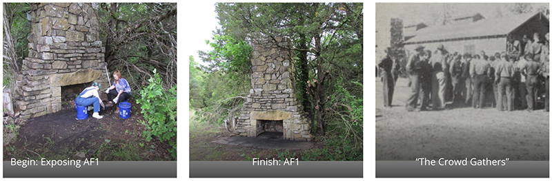
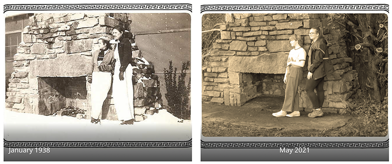
We also have a couple photographs of Maude and Faye Blythe (cousins to the Halsey family) in January 1938 playing in the snow at the camp. The images are part of the Faulkner County Historical Collection, now part of the photograph collection (P-4) at UCA Archives. One photo shows the two women posing in front of the AF1 chimney with the Recreation Center building still attached. After exposing AF1, students had fun replicating the photo!
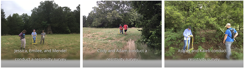
Students were also exposed to electrical resistivity survey methods using an RM Frobisher TAR-3 resistance meter. Over the course of two weeks, they were able to collect numerous grids, adding to data collection from previous years. Efforts were focused in the area in which the former barracks were located as well as a large open space where several additional buildings of unknown use were located. Results offer several areas for exploration in subsequent field schools.
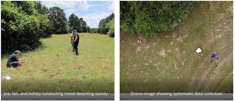
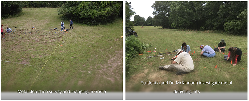
Finally, students were also introduced to the use of systematic metal detection survey methods. Two 10 x 10 grids (also surveyed with resistivity) were surveyed. Students used pin-flags to mark metal hits, excavate features, and create distribution maps to understand the relationship of identified artifacts (lots of nails!) and the proposed location of the former buildings.
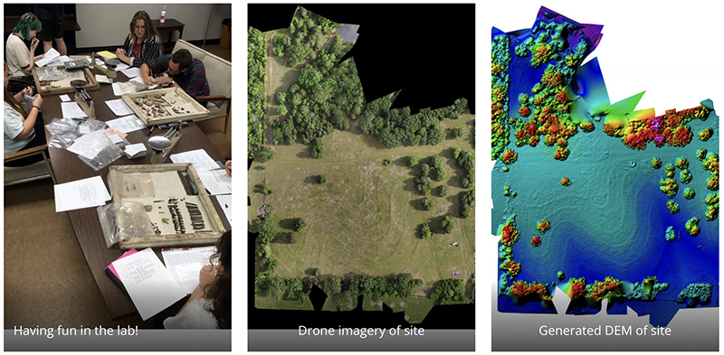
After collecting data in the field, the last few days were spent in the Archaeology Lab on UCA campus. Students were exposed to artifact cleaning, documentation, sorting, interpretation, and accessioning and curation standards. Artifacts were “bagged and tagged” according to Arkansas Archeological Survey standards.
Students also had the opportunity to understand spatial data processing related to electrical resistivity, drone photogrammetry, and processes associated to the digitization of field maps and features.
And a good time was had by all!

Group photo on the final day.
Field Work, May 16-June 3, 2022

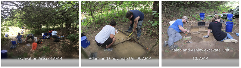
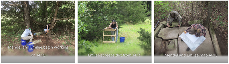
The 2022 UCA Field Archaeology course has officially concluded! As with previous field seasons, we had a very productive year with lots of new data collected, skills learned, and knowledge gained regarding Camp Halsey (3FA313) and the occupational history of the site. This season, three new architectural features (AF14, AF15, and AF16) were excavated and documented. Additionally, students gained experience in field reporting, feature mapping, systematic metal detecting, artifact field documentation and cataloging, total station mapping, site grid organization, and electrical resistivity survey method and data processing.
Architectural Feature 14 (AF14) is defined as a low topographic rise located in the southeast corner of the camp. After clearing vegetation, two 1×2 m units were opened (Unit 9 and 10) in order to cross-cut the topographic rise. Excavations in Unit 9 revealed a row of vertical sandstones, which align with a disturbed cluster of sandstones in Unit 10. When overlain on a 1937 aerial image, they are spatially associated with the location of large building (type and use is unknown at present) and are interpreted as the remains of a stone skirt that surrounded the building base.
Architectural Feature 15 (AF15) was completely consumed by vegetation with only a small portion of a possible foundation visible. After a week of work among poison ivy, the entire feature was exposed, cleaned, mapped, and documented. AF15 is the remains of a poured foundation with foundation walls. Several threaded bolts are within the walls, which are the mounting bolts for a wood building frame that sat over the foundation. Numerous artifacts were recovered (gaskets, washers, nails, wire), including a cache of broken window glass in the northeast corner. Additionally, a well (with water about 8 ft deep) was found in the center of the feature. AF15 represents the location of Camp Building No. 23, Pump House Number 2, where it is noted in the 1938 Building Inventory that on April 1, 1935 an “additional well drilled 50’ South of Barrack No. 12” at a cost of $904.00.
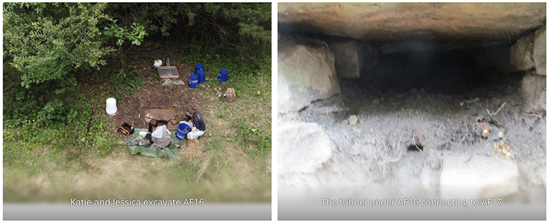
Architectural Feature 16 (AF16) is located directly north of AF15 and represents a stacked-stone culvert on the north side of the former location of Front Street. Today, portions of Front Street are consumed in vegetation with only road ditches visible in some locations. While it was understood as a culvert constructed by the Camp Halsey enrollees, its size and extent were unknown. A 1×1 unit (Unit 11) was opened in order to explore these questions. When fully exposed, the culvert represents a very sturdy and robust covert that seemingly continues under the road and likely connects to Feature 17 (AF17) – a cluster of sandstones on the southern side of Front Street. Plans are in place to open a trench between AF16 and AF17 to evaluate their relationship during the 2023 field school season.
Students were also exposed to electrical resistivity survey methods using an RM Frobisher TAR-3 resistance meter. Numerous grids were collected that add to data collection from previous years. A total of 6700 square meters (0.67 hectares; 1. 6 acres) has been collected thus far. Efforts in 2022 were focused in the area in which the former barracks were located, a location across the former Front Street, and a large open space where it is assumed a gas filling station once was located. Results offer several areas for exploration in subsequent field schools.
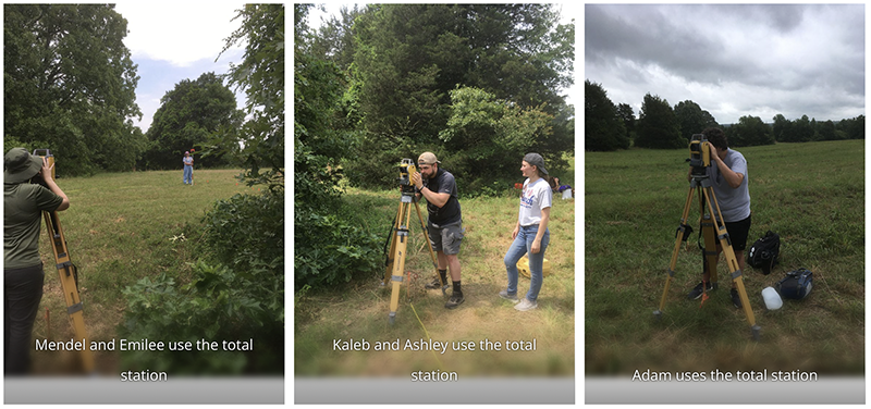
New to the 2022 field school is the permanent addition of a Topcon GM50 Total Station, purchased by the Jamie C. Brandon Center for Archaeological Research from Topcon Solutions. Students had an opportunity to learn how to use a total station to map features, artifact distributions, and topographic data collection. The addition of a total station is an important contribution toward providing students the requisite skills that define an archaeological field school, where total station knowledge is expected by professional archaeology and survey firms.
Finally, students were also introduced to the use of systematic metal detection survey methods. Two 10 x 10 m grids were surveyed within Grid 5. Students used pin-flags to mark metal hits, excavate features, and create distribution maps to understand the relationship of identified artifacts (lots of nails!) and the proposed location of the former buildings.
After collecting data in the field, the last few days were on UCA campus doing lab work. Students were exposed to artifact cleaning, documentation, sorting, interpretation, and accessioning and curation standards. Artifacts were “bagged and tagged” according to Arkansas Archeological Survey standards. They were also introduced to electrical resistivity and total station data processing and geographic information system (GIS) applications. A familiarity of GIS applications is a critical component to archaeological field work and data analysis where a GIS is used to organize multiple data sets and gain insights on spatial relationships between vector and raster data (collected during the field season) and the formation of new hypotheses to test in the field.

Group picture on the last day in the field!
Field Work, May 15-June 2, 2023

The 2023 UCA Field Archaeology course has officially concluded! The fifth year of field school was another productive year with new data collected, skills learned, and knowledge gained regarding Camp Halsey (3FA313), as well as a day spent mapping an undocumented rural cemetery in northern Faulkner County. And, the weather was great… low humidity and no rain! The 2023 fieldwork added to an understanding of the social, historical, economic, and political aspects of the camp and its role in the surrounding Centerville community. The cemetery fieldwork served to record a previously undocumented cemetery (likely mid-late 19th century) and allowed students to apply archaeological methods to address a specific (and time limited) set of hypotheses about a site.
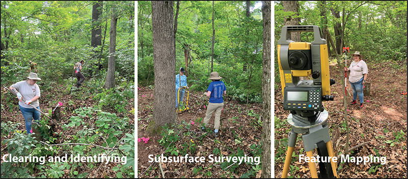
The first week was spent at Camp Halsey where students were exposed to methods associated with site grid, total station mapping, and electrical resistivity survey. Nine 20 x 20 meter survey grids (0.88 acres) were collected using electrical resistivity. This survey method injects a low voltage current into the ground, which measures and maps variable values of electrical resistance (changes in soil porosity) as a result of natural and cultural landform modifications.
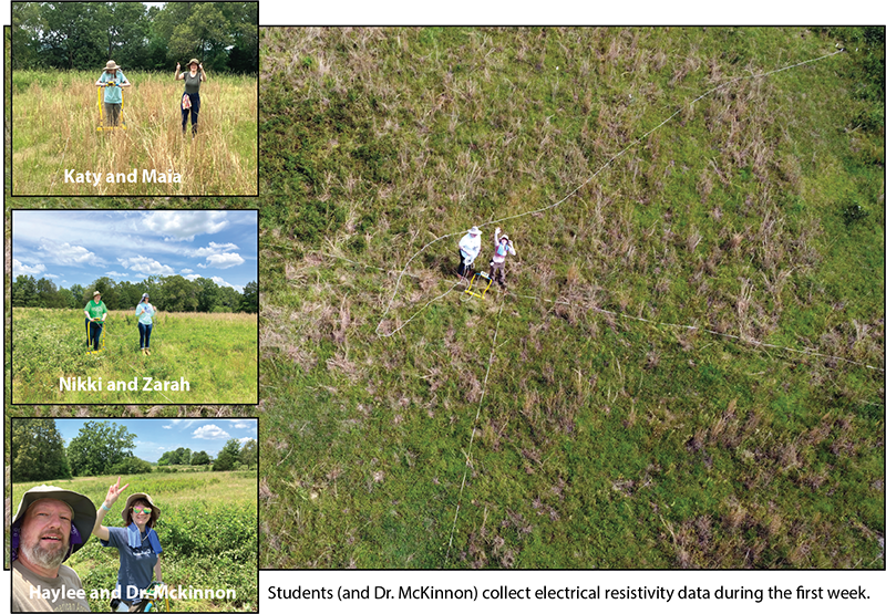
These new survey grids added to the existing resistivity dataset, collected by students during previous field school seasons, and provides an expanded visibility to site activity areas, landscape modifications (terracing), and overall integrity of archaeological remains. Results indicate numerous areas that can be tested during future field schools in order to better understand the organization of the site.
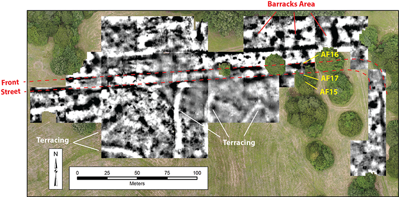
Electrical resistivity survey results collected during the last five years of fieldwork.
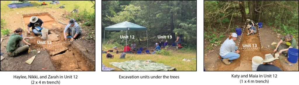
During the second week at Camp Halsey, efforts were focused on re-opening the excavation of Architectural Feature 16 (AF16), first explored during the 2022 season. AF16 was initially interpreted as a road culvert on the north side of the former Front Street. To the south of Front Street is a small cluster of flat stones on the surface that was initially interpreted as the “exit” culvert as water moved under the Front Street roadway and drained to the south (and downslope) of the road. This cluster of flat stones was assigned as AF17 but was not explored in 2022. In 2023, goals were to open an 8-meter long trench (two 4-meter long units; Units 12 and 13) between AF16 and AF17 to better understand the construction of the culvert and its relation to the main street through the camp.
However, excavations revealed that the AF16 culvert is not a simple drainage under the road. It is associated with a complex water management system that captured surface rainwater, as well as rain runoff from the adjoining barracks along Front Street, into a hand-laid stone tunnel (approximately 2 feet tall). As the water moved through the tunnel, it percolated into the ground water and into a dug well associated with the nearby well-house (AF15). AF15 was excavated during the 2022 season as the location of Camp Building No. 23, Pump House Number 2, where it is noted in the 1938 Building Inventory that on April 1, 1935 an “additional well drilled 50’ South of Barrack No. 12” at a cost of $904.00.
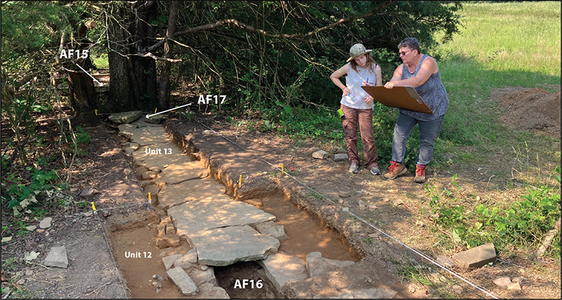
Faulkner County Museum director, Lynita Langley-Ware, and field school student Maia map the completed excavations of the exposed stone tunnel. Remains of the AF15 (well-house) foundation are visible beyond the large tree south of AF17. The well-house nicely aligns with the exposed water management system and AF16 culvert.
n short, 2023 excavations revealed that AF17 was not the remains of an “exit” culvert, but instead were displaced tunnel cover stones that had been pushed up by now-dominating adjoining trees that had grown through the tunnel. The two-foot stone tunnel begins with an open culvert at the north edge of Front Street (AF16), runs south under the shale-lined street, and likely continues beyond the area exposed during this season (Units 12 and 13) under AF17 and toward AF15. Anticipated excavations for the 2024 season will be to expand the trench south of the trees toward the AF15 well-house foundation in order to understand the relationship between the water capture tunnel and the well. The hard work by students this year added to our understanding about landscape modifications at the camp and how water—a scarce resource—was captured and used to support the 200-plus young men living at Camp Halsey between 1934-1935 (Company 1706) and again between 1937-1939 (Company 4748).
Rural Cemetery Work
In addition to work at Camp Halsey, students also had an opportunity to map and record a nearby historic undocumented cemetery in northern Faulkner County. As part of the Faulkner County Historical and Archaeological Resources project, the researchers at the Jamie C. Brandon Center for Archaeological Research and Faulkner County Museum have been mapping and recording historic cemeteries throughout Faulkner County, and making those results available to community members.
During the single day of work at the cemetery, not only were students able to apply archaeological methods during a Phase I “CRM-type” recording and documentation project, but they also had the opportunity to understand how archaeological methods can serve a community need as it relates to documenting the past.
After collecting data at both Camp Halsey and at the rural cemetery, the last few days were on UCA campus doing lab work. Students were exposed to artifact cleaning, documentation, sorting, interpretation, and accessioning and curation standards. Artifacts were “bagged and tagged” according to Arkansas Archeological Survey standards. They were also introduced to electrical resistivity and total station data processing and geographic information system (GIS) applications. A familiarity of GIS applications is a critical component to archaeological field work and data analysis where a GIS is used to organize multiple data sets and gain insights on spatial relationships between vector and raster data (collected during the field season) and the formation of new hypotheses to test during future field seasons.

Group photo! End of the day clearing and documenting an unrecorded rural historic cemetery.